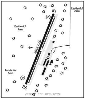
ANACORTES
ANACORTES (74S) 2 W UTC–8(–7DT) N48°29.91′ W122°39.75′ 246 B LRA NOTAM FILE SEA

RWY 18–36: H3018X60 (ASPH–GRVD) S–12.5 MIRL 0.3% up S
RWY 18: REIL. PAPI(P4R)–GA 3.0° TCH 40′. Tree. Rgt tfc.
RWY 36: REIL. PAPI(P4L)–GA 3.0° TCH 43′. Trees.
SERVICE: FUEL 100, JET A LGT ACTIVATE MIRL and REIL Rwy 18 and Rwy 36–CTAF.
NOISE: NS ABTMT procedures in effect, ctc arpt mgr 360–293–3134.
AIRPORT REMARKS: Unattended. Mil arr corridor north and west of arpt. No touch and go ldgs. Rwy 36 preferred calm wind rwy. Deer and coyote near mov areas.
AIRPORT MANAGER: 360-293-3134
COMMUNICATIONS: CTAF 128.25
CLEARANCE DELIVERY PHONE: For CD ctc Whidbey Apch at 360-257-3310.
RADIO AIDS TO NAVIGATION: NOTAM FILE BLI.
WHATCOM (H) (H) VORTACW 113.0 HUH Chan 77 N48°56.72′ W122°34.76′ 167° 27.0 NM to fld. 82/20E.
TACAN AZIMUTH unusable:
155°–165° byd 15 NM blo 6,000′
COMM/NAV/WEATHER REMARKS: CTAF: Automated UNICOM; 122.9. Adzy also avbl at 617–262–3825.