LODI (1O3) 4 N UTC–8(–7DT) N38°12.15′ W121°16.15′
60 B TPA–860(800) NOTAM FILE RIU
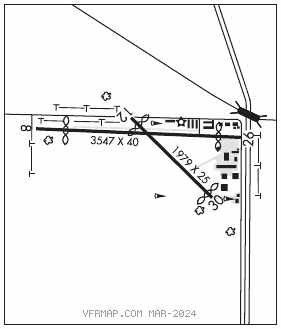
RWY 08–26: H3547X40 (ASPH) S–30 LIRL(NSTD)
RWY 08: Thld dsplcd 515′. Pole.
RWY 26: Thld dsplcd 388′. Pole. Rgt tfc.
RWY 12–30: H1979X25 (ASPH–GRVD) S–30
RWY 12: Thld dsplcd 182′. Tree. Rgt tfc.
RWY 30: Thld dsplcd 102′. Tree.
SERVICE: S4 FUEL 100LL, JET A OX 3 LGT Rwy 08–26 NSTD LIRL located 30′ from pavement edge. EOR lights located at both dsplcd thlds to Rwy 08–26. Rwy 08 edge lgts extended approximately 400′ west of thld.
AIRPORT REMARKS: Attended 1700Z‡–dusk. Parachute Jumping. Automated credit card fuel system 24 hrs a day. Rwy 12–30 pavement is in poor cond, with cracking, raveling, and edges that drop off more than three inches extdg over much of the sfc and sides.
AIRPORT MANAGER: 209-369-9126
COMMUNICATIONS: CTAF 122.9
®NORCAL APP CON 125.1
®NORCAL DEP CON 125.1 (Southbound) 125.25 (Northbound)
CLEARANCE DELIVERY PHONE: For CD ctc NorCal Apch at 916-361-0516.
RADIO AIDS TO NAVIGATION: NOTAM FILE RIU.
LINDEN (VH) (DH) VORW/DME 114.8 LIN Chan 95 N38°04.47′ W121°00.23′ 284° 14.7 NM to fld. 266/17E.
DME unusable:
191°–235°
VOR unusable:
228°–232° byd 40 NM
236°–240° byd 40 NM