PORT TOWNSEND
JEFFERSON CO INTL (0S9) 6 SW UTC–8(–7DT) N48°03.23′ W122°48.64′ 110 B TPA–1000(890) AOE NOTAM FILE SEA
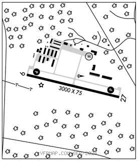
RWY 09–27: H3000X75 (ASPH) S–12.5 MIRL
RWY 09: REIL. PAPI(P2L)–GA 4.25° TCH 43′. Trees. Rgt tfc.
RWY 27: REIL. PAPI(P2R)–GA 4.25° TCH 42′. Tree.
SERVICE: S4 FUEL 100LL LGT ACTVT REIL Rwy 09; PAPI Rwy 09 and 27; MIRL Rwy 09–27–CTAF. PAPI Rwy 09 are baffled byd 6.5 deg left of rwy cntrln due to trrn. PAPI Rwy 27 are baffled byd 6.5 deg right of rwy cntrln due to trrn.
NOISE: Noise abatement procs in efct ctc arpt mgr 360–385–0656.
AIRPORT REMARKS: Attended 1700–0200Z‡. 100LL fuel avbl 24 hrs with credit card. No cash sales. Tkof and lndg prohibited on turf next to rwy. Deer invof rwy.
AIRPORT MANAGER: 360-385-0656
WEATHER DATA SOURCES: AWOS–3P 119.025 (360) 379–1199.
COMMUNICATIONS: CTAF/UNICOM 123.0
APP/DEP CON 118.2
CLEARANCE DELIVERY PHONE: For CD ctc Whidbey Apch at 360-257-3310.
RADIO AIDS TO NAVIGATION: NOTAM FILE PAE.
PAINE (L) (L) VORW/DME 110.6 PAE Chan 43 N47°55.19′ W122°16.67′ 271° 22.9 NM to fld. 669/20E. • • • • • • • • • • • • • • • • • •
HELIPAD H1: H65X65 (ASPH)