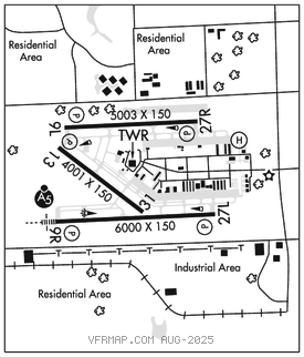
MIAMI EXEC (TMB)(KTMB) 13 SW UTC–5(–4DT) N25°38.85′ W80°25.99′
10 B TPA–See Remarks LRA NOTAM FILE TMB MON Airport

RWY 09R–27L: H6000X150 (ASPH–GRVD) S–87, D–135, 2S–139, 2D–195 PCN 32 F/A/Y/T HIRL
RWY 09R: MALSR. PAPI(P4R)–GA 3.0° TCH 55′. Rgt tfc.
RWY 27L: PAPI(P4L)–GA 3.0° TCH 53′.
RWY 09L–27R: H5003X150 (ASPH–GRVD) S–87, D–135, 2S–139, 2D–195 PCN 32 F/A/Y/T MIRL
RWY 09L: PAPI(P4L)–GA 3.0° TCH 53′.
RWY 27R: PAPI(P2L)–GA 3.0° TCH 40′. Tower. Rgt tfc.
RWY 13–31: H4001X150 (ASPH–GRVD) S–87, D–135, 2S–139, 2D–195 PCN 32 F/A/Y/T MIRL
RWY 13: REIL. PAPI(P4L)–GA 3.0° TCH 40′.
RWY 31: Pole.
SERVICE: S4 FUEL 100LL, JET A OX 2, 3, 4 LGT When ATCT clsd, actvt MALSR Rwy 09R; HIRL Rwy 09R–27L; MIRL Rwy 13–31; twy–CTAF. Rwy 27R PAPI unusbl byd 9 degs left and 7 degs right of cntrln.
NOISE: Noise sensitive arpt; flt trng ltd wkday 1200–0400Z‡; wkend & observed hol 1400–0200Z‡. Noise abatement proc in efct; no turns blw 1,000 ft–305–869–1700.
AIRPORT REMARKS: Attended 1100–0200Z‡. Birds and agricultural ops blw 200′ AGL SR–SS on and invof arpt. Rwy 09L–27R and Rwy 13–31 CLOSED dly 0400–1200Z‡ when Rwy 09R–27L is in use. TPA–Helicopter tfc pat Rwy 09R within fixed wing pat at or blo 500′ AGL. Arpt CLOSED to non–engine acft. Ptns of Twy A btn Spots 1 and 2 and ptns of Twy D btn Spots 14 and 17 and ptns of Twy C btn Spots 13 and 14 not vsb fm ATCT. Simul mov of acft with wingspans in excess of 95′ are precluded fm using parl Twy C and Twy D. SAID in use. Operate transponders with altitude reporting mode and ADS–B (if eqipped) enabled on all airport surfaces. US CBP and EAPIS avbl. 2000–0600Z‡ 305–969–7511. Ops. Mnt freq 118.9 durg CTAF ops.
AIRPORT MANAGER: 305-869-1702
WEATHER DATA SOURCES: ASOS 124.0 (305) 235–1332.
COMMUNICATIONS: CTAF 118.9 ATIS 124.0
TAMIAMI RCO 122.2 (MIAMI RADIO)
®MIAMI APP/DEP CON 125.5
TOWER 118.9 124.9 (270°–090°) (1200–0400Z‡) GND CON 121.7 CLNC DEL 133.0
CLEARANCE DELIVERY PHONE: For CD if una to ctc on FSS freq, ctc Miami Apch at 305-869-5432.
AIRSPACE: CLASS D svc 1200–0400Z‡; other times CLASS E.
RADIO AIDS TO NAVIGATION: NOTAM FILE MIA.
DOLPHIN (VH) (H) VORTAC 113.9 DHP Chan 86 N25°48.00′ W80°20.94′ 211° 10.2 NM to fld. 6/4W.
TACAN AZIMUTH unusable:
055°–065° byd 35 NM blo 3,000′
185°–195° byd 23 NM
226°–236° byd 35 NM
DME unusable:
055°–065° byd 35 NM blo 3,000′
VOR unusable:
034°–037° byd 40 NM
090°–101° byd 40 NM blo 5,500′
090°–101° byd 54 NM
102°–111° byd 40 NM
ILS 108.7 I–TMB Rwy 09R. Class IA. Unmonitored when ATCT clsd. • • • • • • • • • • • • • • • • • •
HELIPAD H1: H75X75 (ASPH)