NEW YORK STEWART INTL (SWF)(KSWF) P (A AR ANG MC) 44 N UTC–5(–4DT) N41°30.25′
W74°06.29′ 491 B TPA–See Remarks Class I, ARFF Index C NOTAM FILE SWF MON Airport

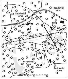
RWY 09–27: H11817X150 (ASPH–GRVD) S–85, D–175, 2S–175, 2D–350, 2D/2D2–775 PCR 733 F/B/X/T HIRL CL
RWY 09: ALSF2. TDZL. PAPI(P4L)–GA 3.0° TCH 65′. RVR–TMR Thld dsplcd 2000′. Fence. 0.4% down.
RWY 27: REIL. PAPI(P4L)–GA 3.0° TCH 56′. RVR–TMR Thld dsplcd 2000′. Tree.
RWY 16–34: H6004X150 (ASPH–GRVD) S–120, D–190, 2S–175, 2D–350, 2D/2D2–800 PCR 733 F/B/X/T HIRL 0.6% up NW
RWY 16: REIL. PAPI(P4L)–GA 3.0° TCH 53′.
RWY 34: REIL. PAPI(P4L)–GA 3.0° TCH 49′. Trees.
RUNWAY DECLARED DISTANCE INFORMATION
RWY 09: TORA–11817 TODA–11817 ASDA–10817 LDA–8817
RWY 16: TORA–6004 TODA–6004 ASDA–6004 LDA–6004
RWY 27: TORA–11817 TODA–11817 ASDA–11817 LDA–9817
RWY 34: TORA–6004 TODA–6004 ASDA–6004 LDA–6004
SERVICE: S4 FUEL 100LL, JET A LGT SFL Rwy 09 O/S UFN. Rwy 16 PAPI unusbl byd 5 degs left of cntrln. MILITARY– JASU 1(MA–1A) 1(M32–60) 1(MD–3) FUEL A++ (Mil), A+ (C845–567–9800) (NC–100LL) TRAN ALERT No tran maint.
NOISE: Noise abatement procedures in effect ctc arpt manager 845–838–8200. Avoid Orange Co. Arpt, located 7 NM west–northwest during VFR apchs. Rgt tfc on Rwy 16 and Rwy 27 may be used for noise abatement.
AIRPORTREMARKS: Attended continuously. Birds and deer on and invof arpt. Extsv glider act 8 mi E of HUO VORTAC in a 5 mi radius. All sfcs: Work in progress grass cutting conducted Apr–Oct. Hudson Valley Rgnl lctd 3.3 NM SW IGN VORTAC, do not mistake for Stewart Intl. TPA–1200(709) hel, 1500(1009) reciprocating eng, 2500(2009) turboprop/jet. Twy L clsd exc 20 minutes PPR. Twy L apron follow me vehicle required. Ctc arpt ops 845–838–8237. Twys B and H restricted to acft with wingspan gtr than 118′. Twy C btn Twy B and Twy F not visible fm twr. Twy C rstrd to acft with wingspan gtr than 125 ft btn trml bldg and bldg 118. Acft with wingspan 172 ft or more rqr vehicle escort for all Twy C opns S of trml apn. Txl C not vsb to twr for acft pushback fm pax trml; ctc gnd freq for pushback onto txl C. Ctc arpt opns 845–838–8237. No jet trng 0400–1200Z‡ dly. Rwy 16 and Rwy 34 has mil assault ldg zone and basic mkgs with aiming points. Rwy 09 VGSI and ILS glidepath not coincident. Compass calibration pad lctd on the Twy G runup apron. User fee arpt. User fee charged to all intl flts. Flight Notification Service (ADCUS) avbl. Ldg fee per 1000 lbs certificated gross max TOG.
AIRPORT MANAGER: 845-838-8200
COMMUNICATIONS: ATIS 124.575 845–567–9311 UNICOM 122.95
®NEW YORK APP/DEP CON 132.75
TOWER 121.0 GND CON 121.9
AIRSPACE: CLASS D.
RADIO AIDS TO NAVIGATION: NOTAM FILE ISP.
KINGSTON (VL) (L) VOR/DME 117.6 IGN Chan 123 N41°39.93′ W73°49.33′ 245° 16.0 NM to fld. 581/12W.
VOR unusable:
008°–018° byd 40 NM blo 4,000′
008°–018° byd 70 NM
020°–123° byd 40 NM
045°–050° byd 35 NM blo 4,300′
070°–140° byd 30 NM blo 3,400′
082°–092° byd 20 NM blo 4,000′
082°–092° byd 35 NM blo 5,500′
130°–148° byd 40 NM
203°–216° byd 30NM
243°–253° byd 40 NM
275°–310° byd 40 NM
311°–321° byd 40 NM blo 6,000′
311°–321° byd 64 NM
322°–001° byd 40 NM
NEELY NDB (MHW/LOM) 335 SW N41°29.15′ W74°13.68′ 093° 5.7 NM to fld. 408/14W. NOTAM FILE SWF.
ILS 110.1 I–SWF Rwy 09. Class IIIE. LOM NEELY NDB.
ILS/DME 109.95 I–JKH Chan 36(Y) Rwy 27. Class IB. • • • • • • • • • • • • • • • • • •
HELIPAD H1: H40X40 (ASPH)
HELIPORT REMARKS: Helipad located intersection Twy B and Twy C and east of Twy C.