ST PAUL DOWNTOWN HOLMAN FLD (STP)(KSTP) P (ARNG) 1 S UTC–6(–5DT) N44°56.08′
W93°03.62′ 705 B TPA–1905(1200) LRA NOTAM FILE STP
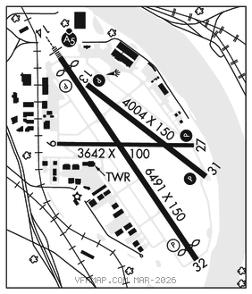
RWY 14–32: H6491X150 (ASPH–GRVD) S–83, D–111, 2D–197 HIRL
RWY 14: MALSR. PAPI(P4R)–GA 3.0° TCH 50′. RVR–TR Thld dsplcd 343′. Road.
RWY 32: REIL. PAPI(P4L)–GA 3.0° TCH 40′. RVR–TR Thld dsplcd 382′. Trees.
RWY 13–31: H4004X150 (ASPH–GRVD) S–97, D–135, 2S–175, 2D–228 HIRL
RWY 13: PAPI(P4L)–GA 3.0° TCH 40′.
RWY 31: REIL. PAPI(P4L)–GA 3.0° TCH 45′. Brush.
RWY 09–27: H3642X100 (ASPH) S–12.5, 2S–175 MIRL
RWY 09: Tree.
RWY 27: PAPI(P4R)–GA 4.0° TCH 40′. Tree. Rgt tfc.
RUNWAY DECLARED DISTANCE INFORMATION
RWY 09: TORA–3642 TODA–3642 ASDA–3642 LDA–3642
RWY 13: TORA–4004 TODA–4004 ASDA–4004 LDA–4004
RWY 14: TORA–6491 TODA–6491 ASDA–6491 LDA–6148
RWY 27: TORA–3642 TODA–3642 ASDA–3642 LDA–3642
RWY 31: TORA–4004 TODA–4004 ASDA–4004 LDA–4004
RWY 32: TORA–6491 TODA–6491 ASDA–6491 LDA–6109
ARRESTING GEAR/SYSTEM
RWY 14: EMAS
RWY 32: EMAS
SERVICE: S4 FUEL 100LL, JET A OX 1, 2 LGT When twr clsd, to increase ints and ACTIVATE MALSR Rwy 14, REIL Rwy 31, PAPI Rwy 13, Rwy 27, and Rwy 31, HIRL Rwy 14–32 and Rwy 13–31, MIRL Rwy 09–27–CTAF. PAPI Rwy 14 and Rwy 32 operate continuously. Rwy 13 PAPI unusable byd 4° right of cntrln and inside 0.5 NM. Rwy 14 PAPI unusable byd 8° left of cntrln. Arpt beacon on west edge of arpt. MILITARY–A–GEAR Rwy 14 EMAS 280′ x 162′. Rwy 32 EMAS 225′ x 162′. FUEL JET A ldg fee, ctc FBO. J8(Mil), A (1100–0500Z‡ Mon–Fri; 1300–0400Z‡ Sat–Sun; C651–227–8108, OT PN 4 hr.) (NC–100LL)
NOISE: Voluntary noise abatement procs in efct. See arpt website for more info.
AIRPORT REMARKS: Attended continuously. Deer, birds and wildlife on and invof arpt. Arpt CLOSED to acft over 100,000 lbs. Complex airport geometry. Verify correct compass heading prior to departure. Cold temperature airport. Altitude correction required at or below –30C. PPR acft over 100,000 lbs, ctc arpt manager. Rwy 14 is calm wind rwy when twr clsd. When using Rwy 27 or Rwy 31, hazardous river tfc may exist. Southeast arrivals and departures avoid tfc pattern ops at South St. Paul arpt 164° 5 NM at and blo 1720′ MSL. Twy A clsd between Twy A3 and Twy A4 except for wingspan less than 101′. Expect helicopter ops on Twy A invof the ctrl twr, north to the apch end of Rwy 14. Twy B clsd between MN jet ramp and Twy A (southern corner) except for wingspan less than 72′ due to flood wall obstacle. Flight Notification Service (ADCUS) avbl. Ldg fee.
AIRPORT MANAGER: 651-224-4306
WEATHER DATA SOURCES: ASOS 118.35 (651) 312–8888. LAWRS.
COMMUNICATIONS: CTAF 119.1 ATIS 118.35 UNICOM 122.95
®MINNEAPOLIS APP/DEP CON 121.2
ST PAUL TOWER 119.1 (1200–0400Z‡ Mon–Fri, 1300–0400Z‡ Sat–Sun)
GND CON 121.675 CLNC DEL 121.675
MINNEAPOLIS APCH CONTROL CLNC DEL 121.675 (0400–1200Z‡ Mon–Fri, 0400–1300Z‡ Sat–Sun)
ARNG OPS 126.2 347.7
AIRSPACE: CLASS D svc 1200–0400Z‡ Mon–Fri, 1300–0400Z‡ Sat–Sun; other times CLASS E.
VOR TEST FACILITY (VOT) 114.4
RADIO AIDS TO NAVIGATION: NOTAM FILE PNM.
GOPHER (VH) (H) VORTACW 117.3 GEP Chan 120 N45°08.74′ W93°22.39′ 127° 18.4 NM to fld. 877/6E.
VOR unusable:
025°–080° blo 5,000′
061°–071° byd 40 NM
067°–080° byd 47 NM blo 3,000′
067°–080° byd 70 NM blo 12,000′
239°–277° byd 40 NM blo 18,000′
240°–260° byd 5 NM
275°–285° byd 10 NM blo 4,000′
330°–345° byd 13 NM blo 3,000′
TACAN AZIMUTH unusable:
025°–080° blo 5,000′
145°–155° byd 37 NM blo 3,800′
230°–250° byd 38 NM blo 3,400′
275°–285° byd 10 NM blo 4,000′
330°–345° byd 13 NM blo 3,000′
DME unusable:
145°–155° byd 37 NM blo 3,800′
275°–285° byd 10 NM blo 4,000′
330°–345° byd 13 NM blo 3,000′
ILS/DME 111.5 I–VKG Chan 52 Rwy 14. Class IB. Unmonitored when twr clsd. LOC unusable 9° right of course. Glideslope unusable 4° left or right of course. LOC unusable byd 6° left of course.
ILS/DME 111.5 I–BAO Chan 52 Rwy 32. Class IA. DME unusable blo 3,500′ byd 25° left of course. Unmonitored when twr clsd.
COMM/NAV/WEATHER REMARKS: Emerg frequency 121.5 not avbl at twr.