STEVENS POINT MUNI (STE)(KSTE) 3 NE UTC–6(–5DT) N44°32.71′ W89°31.82′
1110 B NOTAM FILE STE
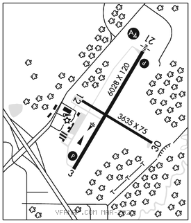
RWY 03–21: H6028X120 (ASPH) S–30, D–75, 2D–195 HIRL
RWY 03: REIL. PAPI(P2L)–GA 3.0° TCH 44′. Trees.
RWY 21: MALS. PAPI(P4L)–GA 3.0° TCH 45′. Trees.
RWY 12–30: H3635X75 (ASPH) S–9, D–75 HIRL
RWY 12: Trees.
RWY 30: Trees.
SERVICE: FUEL 100LL, JET A+ LGT HIRL on actv rwy preset to low SS–SR; to incr intst and ACTVT MALS Rwy 21; REIL Rwy 03; PAPI Rwy 03 and 21; HIRL Rwy 03–21 and Rwy 12–30–CTAF.
AIRPORTREMARKS: Attended 1330–2230Z‡ hrs Mon–Fri, on call Sat–Sun. Aft hrs call 715–345–8989; option 3. Migratory waterfowl on and invof arpt. 100LL: 24 hr self svc fuel avbl with credit card.
AIRPORT MANAGER: 715-345-8993
WEATHER DATA SOURCES: AWOS–3 119.275 (715) 344–5960.
COMMUNICATIONS: CTAF/UNICOM 122.7
®MINNEAPOLIS CENTER APP/DEP CON 124.4
CLEARANCE DELIVERY PHONE: For CD ctc Minneapolis ARTCC at 651-463-5588.
RADIO AIDS TO NAVIGATION: NOTAM FILE LSE.
ILS/DME 111.35 I–STE Chan 50(Y) Rwy 21. Class IE. Unmonitored. Glideslope unusable for cpd apch blw 1,400′ MSL.