ST CLOUD SKY CENTRAL (STC)(KSTC) 4 E UTC–6(–5DT) N45°32.77′ W94°03.56′
1031 B ARFF Index–See Remarks NOTAM FILE STC
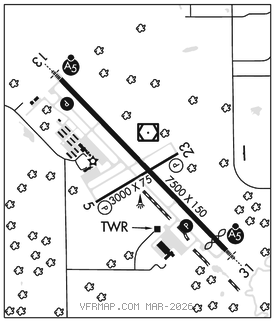
RWY 13–31: H7500X150 (CONC–GRVD) S–75, D–175, 2S–175, 2D–280 PCR 380 R/A/W/T HIRL
RWY 13: MALSR. PAPI(P4R)–GA 3.0° TCH 50′.
RWY 31: MALSR. PAPI(P4L)–GA 3.0° TCH 50′. Thld dsplcd 500′.
RWY 05–23: H3000X75 (ASPH) S–50, D–75, 2S–95 PCR 28 F/A/X/T MIRL No Part 121/Part 380 Ops
RWY 05: PAPI(P4R)–GA 3.0° TCH 31′.
RWY 23: PAPI(P4L)–GA 3.0° TCH 30′.
RUNWAY DECLARED DISTANCE INFORMATION
RWY 05: TORA–3000 TODA–3000 ASDA–3000 LDA–3000
RWY 13: TORA–7500 TODA–7500 ASDA–7000 LDA–7000
RWY 23: TORA–3000 TODA–3000 ASDA–3000 LDA–3000
RWY 31: TORA–7500 TODA–7500 ASDA–7500 LDA–7000
SERVICE: S4 FUEL 100LL, JET A OX 1 LGT ACTVT MALSR Rwy 13 and 31–CTAF. PAPI 13 and 31; HIRLRwy 13–31; MIRLRwy 05–23 preset on low intst, to incr intst and ACTVT–CTAF.
AIRPORT REMARKS: Attended 1100–0530Z‡. Deer, migratory waterfowl and other wildlife on and invof arpt. Crop dusting operations on invof arpt during summer months. Line of sight visibility is restricted from the Rwy 13 and 23 approach and Rwy 13 and 05 approach. Helipad not visible from ATCT and approach surfaces. Class I, ARFF Index B. 24 hrs PPR for unscheduled air carrier ops with more than 30 passenger seats call arpt manager 320–255–7292. Flight training on and invof arpt. Rwy 31 calm wind rwy. Rwy 13–31 200′ blast pad each end.
AIRPORT MANAGER: 320-255-7292
WEATHER DATA SOURCES: ASOS 125.075 (320) 200–1187.
COMMUNICATIONS: CTAF 118.25 ATIS 119.375
RCO 122.5 (PRINCETON RADIO)
®MINNEAPOLIS CENTER APP/DEP CON 121.05
TOWER 118.25 (1300–0500Z‡) GND CON 123.75
CLEARANCE DELIVERY PHONE: For CD when ATCT is clsd ctc FSS via rco, if una ctc Minneapolis ARTCC at 651-463-5588.
AIRSPACE: CLASS D svc 1300–0500Z‡; other times CLASS E.
RADIO AIDS TO NAVIGATION: NOTAM FILE STC.
(T) (T) VORW/DME 112.1 STC Chan 58 N45°32.96′ W94°03.52′ at fld. 1023/3E. VOR unmonitored.
HUSSK NDB (LOMW) 342 ST N45°28.74′ W93°58.12′ 314° 5.6 NM to fld. 985/3E.
ILS 111.9 I–BPM Rwy 13. Class IB.
ILS 111.9 I–STC Rwy 31. Class IB. LOM HUSSK NDB. Autopilot cpd apch NA blw 1,600′.