SILER CITY MUNI (SCR)(KSCR) 3 SW UTC–5(–4DT) N35°42.26′ W79°30.26′
616 B NOTAM FILE RDU
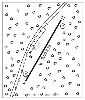
RWY 04–22: H5000X75 (ASPH) S–25 MIRL 0.3% up NE
RWY 04: REIL. PAPI(P4L)–GA 4.2° TCH 40′. Trees.
RWY 22: REIL. PAPI(P4L)–GA 3.5° TCH 45′. Trees.
SERVICE: S4 FUEL 100LL, JET A1+ LGT ACTVT REILS Rwy 04 and 22; MIRL Rwy 04–22–CTAF. PAPI Rwy 04 and 22 oper consly.
AIRPORT REMARKS: Attended Mon–Sat 1400–2200Z‡, Sun 1700–2200Z‡. Deer and birds on and invof arpt. Seasonal farming ops and equipment invof rwy. Aft hrs fuel or svcs, call 919–619–2707. 24 hr credit card svc avbl for 100LL and Jet A. Asph section of ramp pavement strength is csdrbly less than rwy.
AIRPORT MANAGER: 919-742-3847
WEATHER DATA SOURCES: AWOS–3 125.775 (919) 663–1252.
COMMUNICATIONS: CTAF/UNICOM 122.7
®GREENSBORO APP/DEP CON 126.6
CLEARANCE DELIVERY PHONE: For CD ctc Greensboro Apch at 336-333-5119.
RADIO AIDS TO NAVIGATION: NOTAM FILE RDU.
LIBERTY (VL) (L) VORTAC 113.0 LIB Chan 77 N35°48.70′ W79°36.76′ 144° 8.3 NM to fld. 828/3W.