STAPLES MUNI (SAZ)(KSAZ) 2 NW UTC–6(–5DT) N46°22.85′ W94°48.40′
1288 B NOTAM FILE SAZ
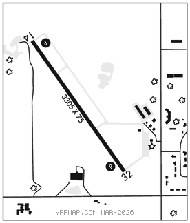
RWY 14–32: H3305X75 (ASPH) MIRL
RWY 14: REIL. PAPI(P4L)–GA 3.0° TCH 27′. Tree.
RWY 32: REIL. PAPI(P4L)–GA 3.0° TCH 27′. Tree.
SERVICE: FUEL 100LL LGT ACTIVATE REIL Rwy 14 and Rwy 32; PAPI Rwy 14 and Rwy 32; MIRL Rwy 14–32 –CTAF.
AIRPORT REMARKS: Unattended. Ultralight tfc on and invof arpt. 100LL avbl H24 self svc via credit card.
AIRPORT MANAGER: 218-894-2550
WEATHER DATA SOURCES: AWOS–3 118.325 (218) 894–3666.
COMMUNICATIONS: CTAF 122.9
®MINNEAPOLIS CENTER APP/DEP CON 118.05
GCO 121.725 (MINNEAPOLIS CENTER and FLIGHT SERVICES)
CLEARANCEDELIVERY PHONE:For CD if una via GCO ctc Minneapolis ARTCC at 651-463-5588.
RADIO AIDS TO NAVIGATION: NOTAM FILE AXN.
ALEXANDRIA (VL) (DH) VORW/DME 115.95 AXN Chan 106(Y) N45°57.50′ W95°13.96′ 028° 31.0 NM to fld. 1367/7E.
VOR unusable:
045°–060° byd 30 NM blo 6,400′
DME unusable:
045°–060° byd 30 NM blo 6,400′
146°–153° byd 15 NM