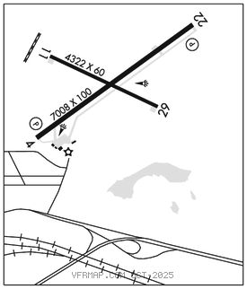
RAWLINS MUNI/HARVEY FLD (RWL)(KRWL) 2 NE UTC–7(–6DT) N41°48.34′ W107°12.02′
6817 B NOTAM FILE RWL

RWY 04–22: H7008X100 (ASPH–GRVD) S–30, D–60 MIRL 1.0% up NE
RWY 04: PAPI(P4L)–GA 3.0° TCH 44′. Tank. Rgt tfc.
RWY 22: REIL. PAPI(P4L)–GA 3.0° TCH 44′.
RWY 11–29: H4322X60 (ASPH) S–12 MIRL 0.7% up W
RWY 29: REIL. Rgt tfc.
SERVICE: FUEL 100LL, JET A LGT Actvt REIL Rwy 22 and 29; MIRL Rwy 04–22 and Rwy 11–29–CTAF. PAPI Rwy 04 and 22 opr consly.
NOISE: Req all acft departing Rwy 29 make rgt turnout as soon as safety permits after tkf to avoid housing area and for noise abatement.
AIRPORT REMARKS: Attended Mon–Fri 1400–0200Z‡, Sat–Sun 1400–0000Z‡. Birds invof arpt rwys. Phone nr for fuel aft hrs posted on FBO door. Rwy 11–29 ltd to acft up to 12,000 lbs GWT.
AIRPORT MANAGER: 307-321-5566
WEATHER DATA SOURCES: ASOS 118.525 (307) 328–0031.
COMMUNICATIONS: CTAF/UNICOM 123.0
RCO 122.2 (CASPER RADIO)
®DENVER CENTER APP/DEP CON 132.1
CLEARANCE DELIVERY PHONE: For CD if una to ctc on FSS freq, ctc Denver ARTCC at 303-651-4257.
AIRSPACE: CLASS E svc 1300–0500Z‡; other times CLASS G.
RADIO AIDS TO NAVIGATION: NOTAM FILE CPR.
CHEROKEE (VH) (H) VORW/DME 115.0 CKW Chan 97 N41°45.34′ W107°34.92′ 065° 17.4 NM to fld. 705015E.
VOR unusable:
000°–015° byd 40 NM
082°–085° byd 40 NM
114°–116° byd 40 NM
125°–135° byd 40 NM