MARSHALL
BROOKS FLD (RMY)(KRMY) 1 S UTC–5(–4DT) N42°15.07′ W84°57.33′ 941 B TPA–1941(1000) NOTAM FILE RMY
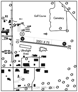
RWY 10–28: H3501X75 (ASPH) S–12.5 MIRL
RWY 10: PAPI(P4L)–GA 4.0° TCH 25′.
RWY 28: PAPI(P4R)–GA 4.0° TCH 37′. Trees.
SERVICE: S4 FUEL 100LL, UL94 LGT ACTVT PAPI Rwy 10 & 28; MIRL Rwy 10–28; nstd perimeter lgts helipad H1–CTAF. Helipad nstd perimeter lgts due to color.
AIRPORT REMARKS: Attended 1300Z‡–dusk, exc major hols. Deer & lrg birds on & invof arpt. Glider and ultralight activity on and invof arpt summer months. Ultralight acft fly left hand pattern 500′ AGL, south of Rwy 10–28. For snow removal Helipad H1 call amgr. Admin bldg aces, press 5–3–2–1.
AIRPORT MANAGER: 269-330-2908
WEATHER DATA SOURCES: AWOS–3P 120.025 (269) 781–9070.
COMMUNICATIONS: CTAF/UNICOM 122.8
®GREAT LAKES APP/DEP CON 119.2 (1030–0500Z‡)
®CHICAGO CENTER APP/DEP CON 127.55 (0500–1030Z‡)
CLEARANCE DELIVERY PHONE: For CD ctc Great Lakes Apch at 269-459-3344, when Apch clsd ctc Chicago ARTCC at 630-906-8921.
RADIO AIDS TO NAVIGATION: NOTAM FILE JXN.
JACKSON (DH) DME 115.45 JXN Chan 101(Y) N42°15.55′ W84°27.51′ 269° 22.1 NM to fld. 994.
DME unusable:
180°–210° byd 30 NM blo 3,500′
• • • • • • • • • • • • • • • • • •
HELIPAD H1: H100X100 (CONC) S–12.5 RWY LGTS(NSTD)
HELIPORT REMARKS: Nstd perimeter lgts due to color. For snow removal helipad H1 call amgr. 150 ft lgtd water twr 3000 ft south of helipad.