PATTERSON
HARRY P WILLIAMS MEML (PTN)(KPTN) 2 NW UTC–6(–5DT) N29°42.57′ W91°20.34′ 9 B LRA NOTAM FILE PTN
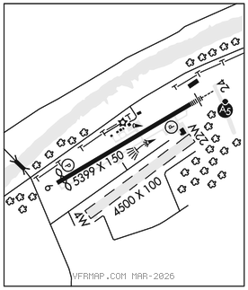
RWY 06–24: H5399X150 (ASPH) S–32 MIRL
RWY06: REIL. PAPI(P2L)–GA 3.0° TCH 50′. Thld dsplcd 394′. Trees.
RWY 24: MALSR. PAPI(P2L)–GA 3.0° TCH 50′. Rgt tfc.
SERVICE: S4 FUEL 100LL, JET A LGT ACTVT MALSR Rwy 24; MIRL Rwy 06–24 preset med intst, to incr intst–CTAF.
AIRPORTREMARKS:Attended continuously. Pilots conducting EFVS ops; be aware LED ALS in use Rwy 24. 4500 ft by 100 ft waterwy hdg 04–22 lctd 1100 ft south of conc rwy. Dual land/sea operation. Ctc arpt mgr for dsngd ramp space for pub use at arpt.
AIRPORT MANAGER: 337-828-4100
WEATHER DATA SOURCES: AWOS–3PT 134.575 (985) 395–6735.
COMMUNICATIONS: CTAF/UNICOM 122.8
PATTERSON RCO 122.5 (DE RIDDER RADIO)
®NEW ORLEANS APP/DEP CON 124.3
CLNC DEL 124.3
CLEARANCE DELIVERY PHONE: For CD ctc New Orleans Apch at 504-471-4350 or 124.3.
RADIO AIDS TO NAVIGATION: NOTAM FILE DRI.
TIBBY (VL) (DH) VOR/DME 117.15 TBD Chan 118(Y) N29°39.86′ W90°49.75′ 274° 26.8 NM to fld. 102E.
VOR unusable:
244°–255° byd 40 NM
ILS/DME 108.3 I–PTN Chan 20 Rwy 24. Class IA. ILS mnt by FBO durg NMl oprg hrs. • • • • • • • • • • • • • • • • • •
WATERWAY 04W–22W: 4500X100 (WATER)
WATERWAY 04W: Road. Rgt tfc.