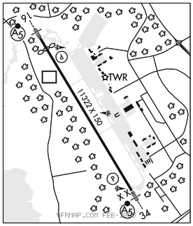
PORTSMOUTH INTL AT PEASE (PSM)(KPSM) P (ANG) 1 W UTC–5(–4DT) N43°04.68′
W70°49.40′ 100 B TPA–See Remarks LRA Class I, ARFF Index B NOTAM FILE PSM

RWY 16–34: H11322X150 (ASPH–CONC–GRVD) S–120, D–250, 2D–550, 2D/2D2–1120 PCR 430 F/A/X/T HIRL
RWY 16: MALSR. PAPI(P4L)–GA 3.0° TCH 72′. RVR–T Thld dsplcd 803′. Trees. Rgt tfc. 0.3% down.
RWY 34: MALSR. PAPI(P4L)–GA 3.0° TCH 80′. RVR–T
RUNWAY DECLARED DISTANCE INFORMATION
RWY 16: TORA–11321 TODA–11321 ASDA–11321 LDA–10518
RWY 34: TORA–11321 TODA–11321 ASDA–11321 LDA–11321
SERVICE: S4 FUEL 100LL, JET A, J8 OX 3, 4 JASU (A/M 32A–86) 9(AM32–95) 5(MA–1A) FUEL J8(Mil) (avbl at ANG 603–430–2459) A, A+ (C603–812–5502; overnight C603–812–5502) (NC–100LL)
FLUID PRESAIR De–Ice LHOX OIL O–148 SOAP; RQR 48 HR processing time. TRAN ALERT Maint and parts support extremely ltd. No drag chute repack. Nml hr 1200–2100Z‡ Mon–Fri, exc hol.
NOISE: Noise sensitive areas off both end of rwy. Avoid close in base legs/short apchs. On dep maintain rwy hdg to 1100′ MSL or the end of the rwy (whichever occurs last) prior to turning.
AIRPORT REMARKS: Attended continuously. Birds on and invof arpt. Turbulence AER 34 in strong cross winds. 200′ blast pad each rwy end. Rwy 34 is preferred when tail wind component is less than 5 kts. Rwy 16 is preferred for tkf btn 0300–1159Z‡, when tail wind component is 5 kts or less. All inbnd acft with hazardous cargo info call twr 60 NM out. Customs 24x7x365 customs clearing availability. Stnd ofc hrs Mon–Fri 1400–2130Z‡. Customs must be arranged in advance at 603–422–0910. Intl arr must arrange for gnd handling prior to arr. FBO 603–430–1111/128.825 ARINC. No practice low apch or touch and go ldg 0400–1200Z‡ for lcl based acft and 0200–1200Z‡ for tran acft or before 1700Z‡ Sun for all acft. Dur snow removal ops PPR 15 minutes on 128.4 and no practice low apch or touch and go ldg. On other than a published IAP arr acft should establish themselves on final apch at least 2 NM from the rwy thld at a minimum of 700′ MSL. Littlebrook Airpark lctd 052° 4.4 NM, TPA–1130′ MSL. Fly downwind leg no closer than 1/2 mile from rwy. Rectangular TPA–1600(1500), overhead TPA–2100(2000), lgt acft 1100(1000). Rwy 16 fst 600′ conc–grooved. No 180° turns for acft over 12,500 lbs GWT on asph portion of Rwy 16–34. Rwy 16–34 double faced distance markers both sides of rwy at 1000′ intervals. Rwy 16–34 edge lgts are 24" tall, 85′ from cntrln. Caution: Height group 1 WCH 54′. Index E ARFF capability avbl 24/7. 157 ARW is fully opr KC46 Base.
AIRPORT MANAGER: 603-433-6536
WEATHER DATA SOURCES: ASOS USAF AN/FMQ–19.
COMMUNICATIONS: ATIS 132.05 603–334–6070 UNICOM 122.95
®BOSTON APP/DEP CON 125.05
TOWER 128.4 GND CON 120.95
AIRSPACE: CLASS D.
RADIO AIDS TO NAVIGATION: NOTAM FILE PSM.
PEASE (L) DME 116.5 PSM Chan 112 N43°05.07′ W70°49.92′ at fld. 108.
DME unusable:
029°–071° byd 35 NM blo 2,500′
080°–085° byd 35 NM blo 2,500′
115°–120° byd 37 NM blo 2,500′
190°–205° byd 35 NM blo 2,500′
225°–240° byd 25 NM blo 2,500′
ILS 110.1 I–PGQ Rwy 16. Class IA.
ILS 110.1 I–PSM Rwy 34. Class IB.
ASR/PAR