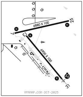
PIERRE RGNL (PIR)(KPIR) 3 E UTC–6(–5DT) N44°22.96′ W100°17.16′
1744 B ARFF Index–See Remarks NOTAM FILE PIR MON Airport

RWY 13–31: H6900X100 (ASPH–GRVD) S–91, D–108, 2S–137, 2D–168 PCR 421 F/D/W/T HIRL
RWY 13: REIL. PAPI(P4L)–GA 3.0° TCH 52′.
RWY 31: MALSR. PAPI(P4L)–GA 3.0° TCH 55′.
RWY 07–25: H6880X100 (ASPH–GRVD) S–91, D–114, 2S–145, 2D–180 PCR 515 F/D/X/T HIRL 0.6% up W
RWY 07: REIL. PAPI(P4L)–GA 3.0° TCH 51′. Tank.
RWY 25: REIL. PAPI(P4L)–GA 3.0° TCH 57′.
RUNWAY DECLARED DISTANCE INFORMATION
RWY 07: TORA–6880 TODA–6880 ASDA–6880 LDA–6880
RWY 13: TORA–6900 TODA–6900 ASDA–6900 LDA–6900
RWY 25: TORA–6880 TODA–6880 ASDA–6880 LDA–6880
RWY 31: TORA–6900 TODA–6900 ASDA–6900 LDA–6900
SERVICE: S4 FUEL 100LL, JET A OX 1, 2, 3, 4 LGT ACTIVATE MALSR Rwy 31; REIL Rwy 07, Rwy 13 and Rwy 25; PAPI Rwy 07, Rwy 25, Rwy 13 and Rwy 31; HIRL Rwy 07–25 and Rwy 13–31–CTAF.
AIRPORT REMARKS: Attended Mon–Fri 1100–0600Z‡, Sat–Sun 1100–0400Z‡. For attendant otr times call 605–224–9000. Birds on and invof arpt and wi 25 NM radius. Arpt cond unmon at ngt fm last acr arr/dep till 1100Z‡. No line of sight between rwy ends of Rwy 07–25. Twy C is 50′ wide and restrd to acft 75000 pounds or less. Class I, ARFF Index B. ARFF coverage provided durg sked acr ops; 24 hrs PPR for unsked acr ops with more than 30 passenger seats call arpt ops–605–773–7476/7405. NOTE: See Special Notices Section–Aerobatic Practice Areas.
AIRPORT MANAGER: 605-773-7447
WEATHER DATA SOURCES: ASOS 119.025 (605) 224–6087.
COMMUNICATIONS: CTAF 122.7 UNICOM 122.95
RCO 122.2 (HURON RADIO)
®MINNEAPOLIS CENTER APP/DEP CON 125.1
CLEARANCE DELIVERY PHONE: For CD if una to ctc on freq, ctc Minneapolis ARTCC at 651-463-5588.
AIRSPACE: CLASS E.
RADIO AIDS TO NAVIGATION: NOTAM FILE PIR.
(VL) (H) VORTACW 113.75 PIR Chan 84(Y) N44°23.67′ W100°09.77′ 251° 5.3 NM to fld. 1791/11E.
VOR unusable:
005°–016° byd 40 NM blo 10,000′
005°–016° byd 88 NM
017°–023° byd 40 NM
ILS/DME 111.9 I–PIR Chan 56 Rwy 31. Class IA.