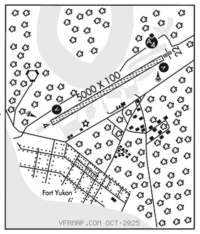
FORT YUKON (FYU)(PFYU) 0 N UTC–9(–8DT) N66°34.35′ W145°14.78′
447 B NOTAM FILE FYU

RWY 04–22: 5000X100 (GRVL–DIRT) MIRL
RWY 04: VASI(V4L)–GA 3.0° TCH 26′. Brush.
RWY 22: MALSF. VASI(V4L)–GA 3.0° TCH 27′. Brush.
SERVICE: FUEL JET A LGT ACTVT MALSF Rwy 22; VASI Rwys 04 and 22; MIRL Rwy 04–22–CTAF.
AIRPORT REMARKS: Unattended. Birds invof landfill 1/4 mi NW of rwy. Rwy cond unmnt, rcmd visual inspection insp bfr lndg. Jet A fuel avbl May–Sep: 907–622–2408. Rwy 04 dep commence at dthr. Snow removal ops mnt CTAF. Twy C reflectors 36 in, unlgt, clsd durg winter. Float plane ops do not cross Rwy 04–22. Tfc pat for hospital lake rmn NW of arpt. Line of sight btn rwy thrs and waterlane NA, mon CTAF spcly bfr dep.
AIRPORT MANAGER: 907-451-5280
WEATHER DATA SOURCES: AWOS–3P 125.8 (907) 662–2337. (WX CAM)
COMMUNICATIONS: CTAF 122.5
RCO 122.05 (FAIRBANKS RADIO)
ANCHORAGE CENTER APP/DEP CON 135.0
SUAIS 125.3 126.3 (1–800–758–8723).
AIRSPACE: CLASS E svc continuous.
RADIO AIDS TO NAVIGATION: NOTAM FILE FYU.
(H) (H) VORTACW 114.4 FYU Chan 91 N66°34.46′ W145°16.60′ at fld. 449/20E.
VOR unusable:
001°–360° byd 15 NM
249°–259° byd 10 NM blo 4,900′
TACAN AZIMUTH unusable:
280°–300° byd 35 NM blo 2,500′
DME unusable:
280°–300° byd 35 NM blo 2,500′
COMM/NAV/WEATHER REMARKS: For a toll free call to Fairbanks FSS dial 1–866–248–6516. Wx obs callsign Fort Yukon Wx–CTAF or 907–662–2948 fm 1600–0400Z‡.