WORTHINGTON MUNI (OTG)(KOTG) 2 N UTC–6(–5DT) N43°39.30′ W95°34.75′
1574 B NOTAM FILE OTG
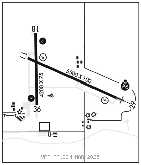
RWY 11–29: H5500X100 (ASPH–GRVD) S–44, D–60 HIRL
RWY 11: REIL. PAPI(P4L)–GA 3.0° TCH 42′.
RWY 29: MALSR. PAPI(P4L)–GA 3.0° TCH 43′.
RWY 18–36: H4200X75 (ASPH–GRVD) S–44, D–60 MIRL
RWY 18: REIL. PAPI(P4L)–GA 3.0° TCH 30′.
RWY 36: REIL. PAPI(P4L)–GA 3.0° TCH 30′.
SERVICE: S3 FUEL 100LL, JET A LGT ACTIVATE MALSR Rwy 29; REIL Rwy 11, Rwy 18 and Rwy 36; PAPI Rwy 18 and Rwy 36; MIRL Rwy 18–36–CTAF. HIRL Rwy 11–29 preset on low ints, to increase ints–CTAF. PAPI Rwy 11 and Rwy 29 opr continuously.
AIRPORT REMARKS: Attended Mon–Fri 1400–2300Z‡. For svc call 507–376–9293, after hrs call 507–360–3731. Self service fuel with credit card. Jet A truck avbl when attended..
AIRPORT MANAGER: 507-372-8650
WEATHER DATA SOURCES: AWOS–3PT 121.075 (507) 376–9441.
COMMUNICATIONS: CTAF/UNICOM 122.8
®MINNEAPOLIS CENTER APP/DEP CON 132.050
AIRSPACE: CLASS E svc 1200–1700Z‡ and 2100–0100Z‡ Mon–Fri, 1200–1700Z‡ Sat, 2100–0100Z‡ Sun; other times CLASS G.
RADIO AIDS TO NAVIGATION: NOTAM FILE OTG.
WONDD NDB (LOMW) 277 OT N43°37.04′ W95°27.85′ 292° 5.5 NM to fld. 15102E.
(L) DME 110.6 OTG Chan 43 N43°38.81′ W95°34.91′ at fld. 1595.
DME unusable:
120°–139° byd 30 NM blo 3,500′
140°–145°
146°–220° byd 30 NM blo 3,500′
220°–305° byd 30 NM blo 4,000′
ILS 111.7 I–OTG Rwy 29. Class IT. LOM WONDD NDB. Autopilot cpd apch NA blw 1,770′.