COLUMBUS MUNI (OLU)(KOLU) 1 NE UTC–6(–5DT) N41°26.92′ W97°20.46′
1447 B NOTAM FILE OLU
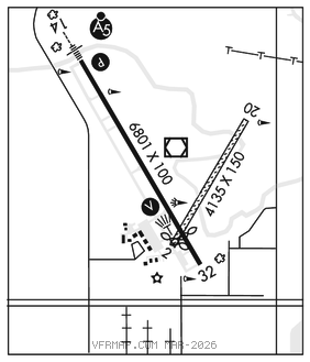
RWY 14–32: H6801X100 (CONC) S–43, D–58 MIRL
RWY 14: MALSR. PAPI(P4L)–GA 3.0° TCH 40′.
RWY 32: REIL. VASI(V4L)–GA 3.0° TCH 44′. Thld dsplcd 950′. Tree.
RWY 02–20: 4135X150 (TURF)
RWY 02: Thld dsplcd 101′.
RUNWAY DECLARED DISTANCE INFORMATION
RWY 14: TORA–6800 TODA–6800 ASDA–6260 LDA–6260
RWY 32: TORA–6800 TODA–6800 ASDA–6800 LDA–5850
SERVICE: S4 FUEL 100LL, JET A LGT ACTVT MIRL Rwy 14–32, PAPI Rwy 14, VASI Rwy 32, REIL Rwy 32, and MALSR Rwy 14–CTAF.
AIRPORT REMARKS: Attended daylight hours. For fuel after hrs ctc 402–910–5246. For svc after dark call 402–564–7884. Deer and waterfowl in vicinity of arpt. Rwy 02–20 not plowed winter months. Rwy 02 end cones mark dsplcd thld; not rwy end. Rwy 32 is designated as the calm wind rwy.
AIRPORT MANAGER: 402-276-5284
WEATHER DATA SOURCES: AWOS–3PT 125.525 (402) 563–3895.
COMMUNICATIONS: CTAF/UNICOM 123.05
RCO 122.2 (COLUMBUS RADIO)
®MINNEAPOLIS CENTER APP/DEP CON 128.75
CLEARANCE DELIVERY PHONE: For CD if una to ctc on FSS freq, ctc Minneapolis ARTCC at 651-463-5588.
AIRSPACE: CLASS E.
RADIO AIDS TO NAVIGATION: NOTAM FILE OLU.
(VL) (L) VORW/DME 116.95 OLU Chan 116(Y) N41°27.00′ W97°20.45′ at fld. 1444/8E.
DME unusable:
180°–260° byd 40 NM
314°–064° byd 15 NM
VOR unusable:
080°–090° byd 40 NM
331°–014° byd 40 NM
LOC 109.1 I–OLU Rwy 14.