OSCEOLA
L O SIMENSTAD MUNI (OEO)(KOEO) 0 SE UTC–6(–5DT) N45°18.56′ W92°41.41′ 906 B NOTAM FILE OEO
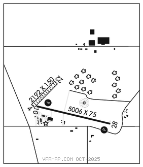
RWY 10–28: H5006X75 (ASPH) S–20, D–30 MIRL 0.4% up E
RWY 10: PAPI(P2L)–GA 3.0° TCH 35′. Road.
RWY 28: REIL. PAPI(P4L)–GA 3.0° TCH 37′.
RWY 04–22: 2192X150 (TURF)
SERVICE: S4 FUEL 100LL, JET A+ LGT MIRL Rwy 10–28 preset on low SS–SR; to incr intst and actvt REIL Rwy 28; PAPI Rwy 10 and 28–CTAF.
AIRPORT REMARKS: Attended Mon–Fri 1500–2200Z‡. Self svc fuel avbl 24 hrs. Glider and ultralight activity on and invof arpt. Deer and birds on and invof arpt. Avoid overflight of St. Croix River National Scenic Bi–way blw 2000 ft AGL exc on takeoff or ldg. Rwy 04–22 clsd to wheeled acft when covered with snow or ice; open to ski equipped acft during winter months. Ctc amgr 612–308–0647. Rwy 04–22 mkd with yellow cones.
AIRPORT MANAGER: 715-294-4500
WEATHER DATA SOURCES: AWOS–3 119.925 (715) 294–3845.
COMMUNICATIONS: CTAF 122.9
®MINNEAPOLIS APP/DEP CON 121.2
GCO 121.725 (MSP CD and FLIGHT SERVICES)
CLEARANCE DELIVERY PHONE: For CD ctc Minneapolis Apch at 612-726-9086.
RADIO AIDS TO NAVIGATION: NOTAM FILE PNM.
GOPHER (VH) (H) VORTACW 117.3 GEP Chan 120 N45°08.74′ W93°22.39′ 065° 30.6 NM to fld. 877/6E.
VOR unusable:
061°–071° byd 40 NM
067°–080° byd 47 NM blo 3,000′
067°–080° byd 70 NM blo 12,000′
239°–277° byd 40 NM blo 18,000′