MARION MUNI – MCKINNEY FLD (MZZ)(KMZZ) 3 SW UTC–5(–4DT) N40°29.40′ W85°40.79′
859 B NOTAM FILE HUF
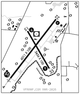
RWY 04–22: H6011X100 (ASPH–GRVD) S–60, D–90, 2D–70 PCN 28 F/C/Y/T HIRL
RWY 04: MALSR.
RWY 22: REIL. PAPI(P4L)–GA 3.0° TCH 42′.
RWY 15–33: H3456X100 (ASPH–GRVD) S–22, D–32 MIRL
RWY 15: REIL. PAPI(P2L)–GA 3.25° TCH 40′. Tree.
RWY 33: REIL. PAPI(P2L)–GA 4.0° TCH 38′. Trees.
SERVICE: S4 FUEL 100LL, JET A OX 2, 4 LGT ACTVT MALSR Rwy 04; REIL Rwy 15, Rwy 22 & Rwy 33; PAPI Rwy 22–CTAF. PAPI Rwy 15 & Rwy 33 on durg day; ACTVT at night–CTAF. HIRL Rwy 04–22; MIRL Rwy 15–33 preset low intst; incr intst–CTAF. Rwy 33 PAPI unusbl byd 9° left of cntrln.
AIRPORT REMARKS: Attended Mon–Fri 1200–2300Z‡, Sat–Sun 1300–2200Z‡. Unattended on Christmas Day. Fuel self svc avbl. Rwy end 33: –12 ft ditch 200 ft L of cntrln; 8–10 ft gnd 230 ft L of cntrln parl S half of rwy.
AIRPORT MANAGER: 765-674-7777
WEATHER DATA SOURCES: AWOS–3 108.6 MZZ (765) 674–1317.
COMMUNICATIONS: CTAF/UNICOM 122.7
®GRISSOM APP/DEP CON 121.05(1230–0400Z‡, other times ctc)
®CHICAGO CENTER APP/DEP CON 121.05
CLNC DEL 120.0
CLEARANCE DELIVERY PHONE: For CD ctc Chicago ARTCC at 630-906-8921.
RADIO AIDS TO NAVIGATION: NOTAM FILE HUF.
(L) (L) VORW/DME 108.6 MZZ Chan 23 N40°29.60′ W85°40.76′ at fld. 854/3W. AWOS–3
ILS 111.7 I–MZZ Rwy 04. Unmonitored.