BEAUFORT
MICHAEL J SMITH FLD (MRH)(KMRH) 1 N UTC–5(–4DT) N34°44.03′ W76°39.62′ 10 B TPA–See Remarks LRA NOTAM FILE MRH
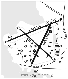
RWY 08–26: H5004X100 (ASPH) D–60 MIRL
RWY 08: REIL. PAPI(P2L)–GA 3.0° TCH 45′. Boat.
RWY 26: REIL. PAPI(P2R)–GA 3.0° TCH 43′. Thld dsplcd 289′. Road. Rgt tfc.
RWY 03–21: H4192X150 (ASPH) S–12.5 MIRL
RWY 03: PAPI(P2L)–GA 4.0° TCH 44′. Thld dsplcd 864′. Road.
RWY 21: PAPI(P2L)–GA 4.0° TCH 54′. Thld dsplcd 516′. Trees. Rgt tfc.
RWY 14–32: H4001X100 (ASPH) S–12.5
RWY 32: Thld dsplcd 490′.
SERVICE: S4 FUEL 100LL, JET A1+ OX3, 4 LGT ACTVT REIL Rwy 08 and 26; PAPI Rwy 03 and 21; MIRL Rwy 03–21 and Rwy 08–26–CTAF. PAPI Rwy 08 and 26 opr continuously.
NOISE: Noise abatement procedures in effect, ctc amgr 252–728–1928. Mil acft Rwy 08–26 required for noise abatement. Avoid overflights of Beaufort Waterfront and Beaufort National Register Historic District.
AIRPORT REMARKS: Attended 1300Z‡–dusk. For service after hours call 843–465–2846. Rwy 14–32 CLSD. Deer and birds on and invof arpt and bird–dropped shells may cause FOD. Skydiving operations – do not overfly arpt. TPA–single engine 1000 ft AGL, twin engine 1500 ft AGL. No line of sight btwn rwy ends.
AIRPORT MANAGER: 252-728-1928
WEATHER DATA SOURCES: ASOS 135.375 (252) 728–2055.
COMMUNICATIONS: CTAF/UNICOM 122.8
®CHERRY POINT APP/DEP CON 132.575
CLNC DEL 125.65
CLEARANCE DELIVERY PHONE: For CD ctc Cherry Point Apch at 252-466-5960.
RADIO AIDS TO NAVIGATION: NOTAM FILE ISO.
KINSTON (VL) (L) VORTAC 117.5 ISO Chan 122 N35°22.26′ W77°33.50′ 136° 58.4 NM to fld. 705W.
VOR unusable:
020°–025° byd 40 NM
040°–115° byd 40 NM
145°–155° byd 40 NM
175°–185° byd 40 NM
183°–215° byd 30 NM blo 5,000′
200°–206° byd 40 NM
207°–214° byd 59 NM
215°–238° blo 3,500′
215°–238° byd 6 NM
238°–258° byd 30 NM blo 5,000′
239°–265° byd 40 NM
280°–290° byd 40 NM
295°–308° byd 40 NM
309°–319° byd 31 NM
320°–325° byd 40 NM
335°–340° byd 40 NM
345°–347° byd 40 NM
348°–358° byd 20 NM
TACAN AZIMUTH unusable:
183°–215° byd 30 NM blo 5,000′
DME unusable:
183°–215° byd 30 NM blo 5,000′
COMM/NAV/WEATHER REMARKS: Due to volume of mil tfc and trng rcmd all acft using MRH ctc Cherry Point App 132.57 AB and 125.65 prior to MRH dep.