MUNCIE
DELAWARE CO RGNL (MIE)(KMIE) 3 NW UTC–5(–4DT) N40°14.55′ W85°23.75′ 937 B ARFF Index–See Remarks NOTAM FILE MIE
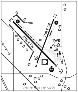
RWY 14–32: H6500X150 (ASPH–GRVD) S–91, D–125, 2S–127, 2D–215 PCR 580 F/D/X/T HIRL
RWY 14: REIL. PAPI(P4L)–GA 3.0° TCH 49′. Trees.
RWY 32: MALSR. Trees.
RWY 03–21: H5198X100 (ASPH–GRVD) S–80, D–100, 2S–127, 2D–125 PCR 640 F/D/X/T MIRL No Part 121/Part 380 Ops
RWY 03: REIL. PAPI(P4L)–GA 3.0° TCH 39′. Tree.
RWY 21: REIL. PAPI(P4L)–GA 3.0° TCH 45′. Tree.
LAND AND HOLD–SHORT OPERATIONS
LDG RWY HOLD–SHORT POINT AVBL LDG DIST
RWY 14 03–21 4300
RWY 21 14–32 3500
RUNWAY DECLARED DISTANCE INFORMATION
RWY 03: TORA–5197 TODA–5197 ASDA–5197 LDA–5197
RWY 14: TORA–6500 TODA–6500 ASDA–6500 LDA–6500
RWY 21: TORA–5197 TODA–5197 ASDA–5197 LDA–5197
RWY 32: TORA–6500 TODA–6500 ASDA–6500 LDA–6500
SERVICE: S2 FUEL 100LL, JET A OX1, 3 LGT ACTVT MALSR Rwy 32; REIL Rwy 03, 14, & 21; PAPI Rwy 14 & 21; MIRL Rwy 03–21; HIRL Rwy 14–32–CTAF. REIL Rwy 03, 14, &21high intsty only. PAPI Rwy 03 on consly.
AIRPORT REMARKS: Attended 1100–0300Z‡. Parachute Jumping. Deer on and invof arpt. Svc aft hrs–(765)–729–1078. Surface conditions not monitored 2000–1200Z‡ M–F and weekend. Rwy 14–32 is calm wind rwy. Class IV, ARFF Index A. Closed to scheduled ACR opns greater than 9 passenger seats. 96 hrs for unsked ACR opns with more than 30 psgr seats call amgr 765–747–5690.
AIRPORT MANAGER: 765-747-5690
WEATHER DATA SOURCES: ASOS 114.4 MIE (765) 288–9617. LAWRS.
COMMUNICATIONS: CTAF 120.1 ATIS 133.25 UNICOM 122.95
®INDIANAPOLIS APP/DEP CON 120.65
MUNCIE TOWER 120.1 (1100–0300Z‡) GND CON 121.9
CLEARANCE DELIVERY PHONE: When ATCT is clsd for CD ctc Indianapolis Apch at 317-227-5743.
AIRSPACE: CLASS D svc 1100–0300Z‡; other times CLASS G.
RADIO AIDS TO NAVIGATION: NOTAM FILE MIE.
MUNCIE (L) (L) VORW/DME 114.4 MIE Chan 91 N40°14.24′ W85°23.64′ at fld. 934/3W. ASOS
DME unusable:
280°–300° byd 10 NM blo 5,000′
VOR unusable:
280°–300° byd 10 NM blo 5,000′
BALLL NDB (LOMW) 365 JN N40°10.86′ W85°19.26′ 320° 5.0 NM to fld. 979/3W.
ILS 109.1 I–JNK Rwy 32. Class IE. LOM BALLL NDB. Unmonitored when ATCT clsd.