MOBERLY
OMAR N BRADLEY (MBY)(KMBY) 3 N UTC–6(–5DT) N39°27.79′ W92°25.55′ 867 B NOTAM FILE COU
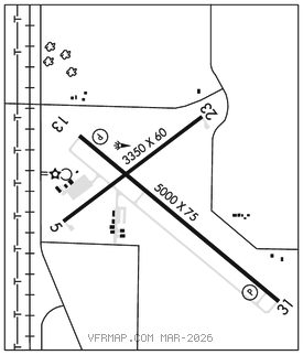
RWY 13–31: H5000X75 (CONC) S–30, D–38 MIRL
RWY 13: REIL. PAPI(P4L)–GA 3.0° TCH 42′.
RWY 31: REIL. PAPI(P4L)–GA 3.0° TCH 42′.
RWY 05–23: H3350X60 (CONC) S–4 MIRL
SERVICE: S4 FUEL 100LL, JET A+ LGT MIRL Rwys 05–23 and 13–31 preset on low ints, to increase ints and ACTIVATE REIL Rwys 13 and Rwy 31–CTAF.
AIRPORT REMARKS: Attended 1400–2300Z‡. Aft hrs ctc 660–998–0134. Fuel: self svc 100LL and Jet A fuel avbl 24 hrs. Sprayer and ultralight acft on and invof arpt.
AIRPORT MANAGER: 660-269-8705
WEATHER DATA SOURCES: AWOS–3PT 120.025 (660) 269–8028.
COMMUNICATIONS: CTAF/UNICOM 122.7
MACON RCO 112.9T (COLUMBIA RADIO)
®KANSAS CITY CENTER APP/DEP CON 132.6
CLEARANCE DELIVERY PHONE: For CD ctc Kansas City ARTCC at 913-254-8508.
RADIO AIDS TO NAVIGATION: NOTAM FILE COU.
MACON (L) DME 112.9 MCM Chan 76 N39°39.24′ W92°28.93′ 167° 11.7 NM to fld. 852.