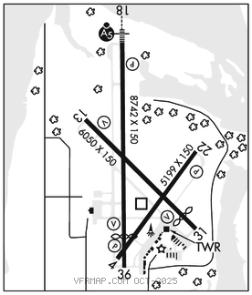
LA CROSSE RGNL (LSE)(KLSE) 4 NW UTC–6(–5DT) N43°52.76′ W91°15.40′
655 B Class I, ARFF Index B NOTAM FILE LSE

RWY 18–36: H8742X150 (CONC–GRVD) S–120, D–200, 2S–175, 2D–340, 2D/2D2–810 PCR 630 R/B/W/T HIRL
RWY 18: MALSR. PAPI(P4L)–GA 3.0° TCH 55′. Tree.
RWY 36: REIL. VASI(V4L)–GA 3.0° TCH 28′. Thld dsplcd 1131′. Tree.
RWY 13–31: H6050X150 (ASPH–GRVD) S–120, D–200, 2S–175, 2D–340 PCR 630 F/A/X/T MIRL
RWY 13: REIL. VASI(V4L)–GA 3.0° TCH 33′. Trees.
RWY 31: REIL. VASI(V4L)–GA 3.85° TCH 44′. Thld dsplcd 739′. Trees.
RWY 04–22: H5199X150 (ASPH) S–90, D–150, 2S–139, 2D–280 PCR 330 F/A/X/T HIRL
RWY 04: PAPI(P4L)–GA 4.0° TCH 29′. Pole.
RWY 22: PAPI(P4L)–GA 4.0° TCH 28′. Trees.
RUNWAY DECLARED DISTANCE INFORMATION
RWY 04: TORA–5199 TODA–5199 ASDA–5199 LDA–5199
RWY 13: TORA–5310 TODA–5310 ASDA–5310 LDA–5310
RWY 18: TORA–8105 TODA–8742 ASDA–8536 LDA–8536
RWY 22: TORA–5199 TODA–5199 ASDA–5199 LDA–5199
RWY 31: TORA–6050 TODA–6050 ASDA–6050 LDA–5310
RWY 36: TORA–8742 TODA–8742 ASDA–8564 LDA–7433
SERVICE: S4 FUEL 100LL, JET A LGT When ATCT clsd MIRL Rwy 13–31 preset low intst; to incr intst & actvt MALSR Rwy 18; REIL Rwy 13, 31, 36; MIRL Rwy 13–31; HIRL Rwy 18–36, Rwy 04–22–CTAF. PAPI Rwy 04, 18, & 22; VASI Rwy 13, 31, & 36 opr consly. Rwy 31 VASI unusbl byd 9 degs right of cntrln.
AIRPORT REMARKS: Attended 1200–0300Z‡. Deer, waterfowl and other birds on and invof arpt. Heavy concentrations of waterfowl spring and fall. For attendant other hrs call 608–783–8359. Cold temperature airport. Altitude correction required at or below –21C. Twr 1390′ AGL 6 NM southwest. Numerous twrs up to 836′ AGL 4 NM southeast. Holding position for the west side of Rwy 36 apch end is set back on Twy C, see HS–1 on arpt diagram. Rwy incursion risk. Pilots are reminded to review arpt hot spot info before taxiing for dep and before landing. See TPP arpt diagram and chart supplement sxn on hot spots for additional info. Wrong rwy arrival risk, Rwy 4 and Rwy 36 apch ends are closely aligned. See TPP arpt diagram. Rwy 04–22 not avbl for skedd acr opns with more than 9 pax seats or unskedd acr at aleast 31 pax seats. Twy A btn Rwy 13–31 and Twy A4; Twy A4 not avbl for skedd acr opns with more than 9 pax seats or unsked acr opns gtr than 30 pax seats. 48 hr PPR for unsked acr ops gtr than 30 pax seats, call AMGR.
AIRPORT MANAGER: 608-789-7456
WEATHER DATA SOURCES: ASOS 124.95 (608) 781–9067.
COMMUNICATIONS: CTAF 118.45 ATIS 124.95 UNICOM 122.95
RCO 122.6 (GREEN BAY RADIO)
®MINNEAPOLIS CENTER APP/DEP CON 128.6
TOWER 118.45 (1200–0300Z‡) GND CON 121.8
CLEARANCEDELIVERYPHONE: For CD when ATCT is clsd ctc on FSS on rco freq; if una ctc Minneapolis ARTCC at 651-463-5588.
AIRSPACE: CLASS D svc 1200–0300Z‡; other times CLASS E.
RADIO AIDS TO NAVIGATION: NOTAM FILE LSE.
(T) DME 108.4 LSE Chan 21 N43°52.57′ W91°15.36′ at fld. 649.
DME unusable:
263°–278° byd 10 NM blo 3,000′
263°–278° byd 15 NM
329°–182°
ILS 111.1 I–LSE Rwy 18. Class IT. Unmonitored when ATCT clsd.