YOUNGSTOWN/WARREN RGNL (YNG)(KYNG) P (AFRC) 10 N UTC–5(–4DT) N41°15.70′
W80°40.82′ 1192 B ARFF Index–See Remarks NOTAM FILE YNG
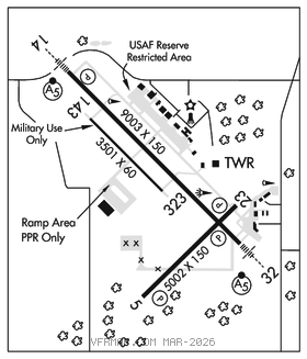
RWY 14–32: H9003X150 (ASPH–GRVD) PCR 1110 F/D/X/T HIRL
RWY 14: MALSR. PAPI(P4L)–GA 3.0° TCH 57′. RVR–R 0.9% up.
RWY 32: MALSR. PAPI(P4L)–GA 3.0° TCH 35′. RVR–T Trees. 0.8% down.
RWY 05–23: H5002X150 (ASPH–GRVD) S–138, D–175, 2S–175, 2D–280 PCR 660 F/D/X/T MIRL 1.4% up NE
RWY 05: REIL. PAPI(P4R)–GA 3.25° TCH 51′. Trees.
RWY 23: REIL. PAPI(P4R)–GA 3.0° TCH 24′.
RWY 143–323: H3501X60 (ASPH) 1.4% up SE
RUNWAY DECLARED DISTANCE INFORMATION
RWY 05: TORA–5002 TODA–5002 ASDA–5002 LDA–5002
RWY 14: TORA–9003 TODA–9003 ASDA–9003 LDA–9003
RWY 143:TORA–3500 TODA–3500 ASDA–3500 LDA–3500
RWY 23: TORA–5002 TODA–5002 ASDA–5002 LDA–5002
RWY 32: TORA–9003 TODA–9003 ASDA–9003 LDA–9003
RWY 323:TORA–3500 TODA–3500 ASDA–3500 LDA–3500
SERVICE: S4 FUEL 100LL, JET A OX 1, 2, 3, 4 LGT Rwy 23 PAPI unusable byd 8° left of rwy centerline. Rwy 32 PAPI unusable byd 8° right of centerline. MILITARY– FUEL J8+100(Mil) J8–PN rqr. (NC–100LL, A) FLUID LOX(Mil) OIL O–156
AIRPORT REMARKS: Attended continuously. Deer and bird haz. All military acft ctc Vader ops for bird watch condition. Rwy 143–323 used as a military assault strip. Class IV, ARFF Index A. Clsd to skedd ACR ops gtr than 9 pax seats. 12 hrs PPR for unsked ACR ops with more than 30 pax seats call arpt ops mgr 330–609–5007. ARFF Index D avbl 12 hrs PPR ctc 330–609–1369. Commercial ramp closed to all general aviation traffic, commercial bdry area defined by red sfc painted marking. Terminal ramp and general aviation parking not visible from the northwest portion of Twy H. Twy J acft turn radius restriction exists for acft having nose gear to main gear distance greater than 64′ and main gear width greater than 30′. Military ramp for military use only. Ldg fee for acft over 5,000 lbs gross weight.
MILITARY REMARKS: RSTD Mil ldg zone 143–323 and mil ramp for mil use only. No practice apch 0300–1300Z‡. Area W of trml and coml ramp clsd to general avn defined by red line on ramp. All mil acft opr rstd dur Bird Watch Cond MODERATE (tkof and ldg perms only when dep/arr rte avoid ident bird act, no lcl IFR/VFR tfc pat act) and SEVERE (tkof and ldg proh wo OG/CC apvl). CAUTION Deer and bird haz, mil acft ctc Vader OPS for bird watch cond. Trees at end Rwy 32. Trml and general avn prk not vis fr NW portion of Twy H. Mil conducting ngt vision device ops Mon–Thu dusk–0400Z‡. MISC FBO line svc avbl 1100–0400Z‡, OT fone C330–442–3374. ARFF oprs in a rdcd lvl of svc sts rglrly. Ctc fire dept DSN 346–1105 or C330–609–1295 prior to arr to dtrm risk factors for your type acft. AFRC PPR for ramp and mil LZ ctc BASOPS 1230–0400Z‡ Mon–Fri exc hols (DT 1130–0400Z) and dur unit trng Sat 1300–2200Z‡ and Sun 1200–2100Z‡. 48 hrs PN for ramp ctc afld mgmt DSN 346–1069/1181, C330–609–1069/1181. Afld mgmt and mil LZ 143/323 open 1230–0400Z‡ Mon–Thu and 1230–0001Z‡ Fri, exc hols, 1200–2100Z‡ Sat and Sun durg unit trng. AMOPS does not issue or stor COMSEC. Ltd COMSEC stor avbl at Comd Post, ctc DSN 346–1315, C330–609–1315 for prior coord. No tran alert svc. Inbd mil acft indicate in rmk DD Form 175 whether prk will be on civ or mil ramp. Tran acft rqr maint will be recovered by home base. Acft security not avbl for C5 RON exc emerg. Mil ldg zone 323 1.4 percent downslope. Mil ldg zone 143 1.4 percent upslope. Aircrews–US CSTMS Svc not immed avbl. All support for CSTMS must be pre–coord at least 72 hr in advance with Afld Mgmt.
AIRPORT MANAGER: 234-228-9696
WEATHER DATA SOURCES: ASOS (330) 967–8953
COMMUNICATIONS: ATIS 123.75 UNICOM 122.95
RCO 122.2 (CLEVELAND RADIO)
®YOUNGSTOWN APP/DEP CON 133.95 (1100–0500Z‡)
®CLEVELAND CENTER APP/DEP CON 120.775 (0500–1100Z‡) ctc Cleveland ARTCC at 440–774–0227.
TOWER 119.5 GND CON 121.9 CLNC DEL 118.25
CLEARANCE DELIVERY PHONE: For CD ctc Youngstown Apch at 330-856-4806, when Apch clsd ctc Cleveland ARTCC at 440-774-0232/0490.
AIRSPACE: CLASS D.
TRSA svc ctc APP CON within 20 NM
RADIO AIDS TO NAVIGATION: NOTAM FILE YNG.
(L) TACAN Chan 27 YNG (109.0) N41°19.86′ W80°40.48′ 189° 4.2 NM to fld. 1158/5W.
FETCH NDB (LOMW) 338 YN N41°12.03′ W80°35.77′ 322° 5.3 NM to fld. 1029/8W. NDB unmonitored.
NDB unusable:
Byd 10 NM
ILS 110.1 I–MQK Rwy 14. Class IE. OM unmonitored.
ILS 110.1 I–YNG Rwy 32. Class IA. LOM FETCH NDB. LOM unmonitored. LOM unusable byd 10 NM.
ASR (1100–0500Z‡)