TROY
OAKLAND/TROY (VLL)(KVLL) 2 E UTC–5(–4DT) N42°32.58′ W83°10.67′ 727 B TPA–1727(1000) NOTAM FILE VLL
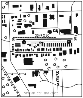
RWY 10–28: H3549X60 (ASPH) MIRL
RWY 10: PAPI(P2R)–GA 3.75° TCH 44′. Tree.
RWY 28: PAPI(P2L)–GA 3.75° TCH 44′. Tree.
SERVICE: FUEL 100LL, JET A+ LGT ACTIVATE PAPI Rwy 10 and Rwy 28 and MIRL Rwy 10–28–CTAF.
AIRPORT REMARKS: Attended 1300–2300Z‡. Deer and lrg birds on and invof arpt. No touch and go landings or practice traffic patterns. Rwy 10 +3′ berm 316′ fm thld.
AIRPORT MANAGER: 248-666-3900
WEATHER DATA SOURCES: AWOS–3P 119.475 (248) 288–4649.
COMMUNICATIONS: CTAF/UNICOM 123.05
®DETROIT APP/DEP CON 132.35
CLEARANCE DELIVERY PHONE: For CD ctc Detroit Apch at 734-955-1404.
RADIO AIDS TO NAVIGATION: NOTAM FILE PTK.
PONTIAC (L) DME 111.0 PSI Chan 47 N42°42.05′ W83°31.97′ 121° 18.4 NM to fld. 1149.
DME unusable:
100°–195° byd 15 NM blo 4,000′
100°–195° byd 30 NM blo 6,000′
355°–070° byd 30 NM blo 3,500′