WAUSEON
FULTON CO (USE)(KUSE) 4 N UTC–5(–4DT) N41°36.59′ W84°07.63′ 781 B NOTAM FILE USE
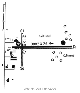
RWY 09–27: H3882X75 (ASPH) S–30 MIRL
RWY 09: REIL. PAPI(P4L)–GA 3.0° TCH 24′. Road.
RWY 27: REIL. PAPI(P4R)–GA 3.0° TCH 33′.
RWY 18–36: H2115X75 (ASPH–TURF)
RWY 36: Tree.
SERVICE: FUEL 100LL, JET A+, UL94 LGT ACTVT REIL Rwy 09 and 27; PAPI Rwy 09 and 27; MIRL Rwy 09–27–CTAF.
AIRPORT REMARKS: Attended Mon–Fri 1400–2200Z‡. For svc aft hrs call amgr. 100LL and UL94 avbl H24 self svc via credit card. Deer and birds on and invof arpt. Rwy 18–36 359 ft of cntr section asph, north 270 ft turf, south 1328 ft turf. Rwy 18–36 turf ptc mkd with white cones. Rwy 27 climb straight out to 1300′ MSL. Restroom access, UNICOM.
AIRPORT MANAGER: 419-335-3993
WEATHER DATA SOURCES: AWOS–3P 127.375 (419) 335–0775.
COMMUNICATIONS: CTAF/UNICOM 123.0
®TOLEDO APP/DEP CON 134.35
CLEARANCE DELIVERY PHONE: For CD ctc Toledo Apch at 419-865-1495.
RADIO AIDS TO NAVIGATION: NOTAM FILE ADG.
ADRIAN NDB (MHW) 278 ADG N41°52.20′ W84°04.65′ 194° 15.8 NM to fld. 799/6W.NDB unmonitored.