NORTH WILKESBORO
WILKES CO (UKF)(KUKF) 4 NE UTC–5(–4DT) N36°13.42′ W81°05.92′ 1303 B NOTAM FILE UKF
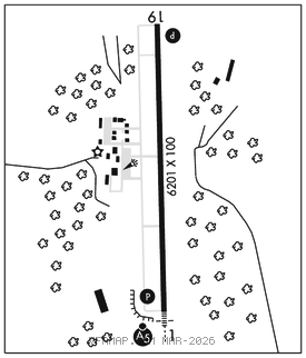
RWY 01–19: H6201X100 (ASPH) S–45, D–60 MIRL 0.9% up N
RWY 01: MALSR. PAPI(P2L)–GA 3.0° TCH 59′. Trees.
RWY 19: REIL. PAPI(P2L)–GA 3.0° TCH 47′. Trees.
SERVICE: S4 FUEL 100LL, JET A1+ OX 3, 4 LGT ACTVT MALSR Rwy 01; REIL Rwy 19; PAPI Rwy 01 and 19; MIRL Rwy 01–19; twy lgts–CTAF. Rwy 01 PAPI unusbl byd 8° right of cntrln.
AIRPORT REMARKS: Attended dawn–dusk. Arpt unattended Thanksgiving and Christmas. Deer on and invof arpt. 100LL: fueling drg rglr FBO bus hrs, plus 24 hrs call–out svc (with prior arrangement and/or a call–out fee), call FBO for details. No line of sight btn rwy ends. There is an unlgtd water tank in the apch of Rwy 01.
AIRPORT MANAGER: 336-696-2000
WEATHER DATA SOURCES: AWOS–3 126.625 (336) 696–3788.
COMMUNICATIONS: CTAF/UNICOM 122.7
WILKESBORO RCO 122.4 (RALEIGH RADIO)
®ATLANTA CENTER APP/DEP CON 125.15
CLEARANCE DELIVERY PHONE: For CD if una to ctc on FSS freq, ctc Atlanta ARTCC at 770-210-7692.
RADIO AIDS TO NAVIGATION: NOTAM FILE RDU.
BARRETTS MOUNTAIN (H) (H) VOR/DME 113.75 BZM Chan 84(Y) N35°52.13′ W81°14.43′ 024° 22.3 NM to fld. 18806W.
VOR unusable:
030°–040° byd 15 NM blo 8,500′
107°–117° byd 30 NM
ILS/DME 111.55 I–UKF Chan 52(Y) Rwy 01. Class IB. DME unusable byd 15° left of centerline.