DODGE CENTER (TOB)(KTOB) 1 SE UTC–6(–5DT) N44°01.08′ W92°49.90′
1304 B NOTAM FILE TOB
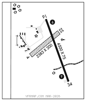
RWY 16–34: H4500X75 (CONC) MIRL
RWY 16: REIL. PAPI(P4L)–GA 3.0° TCH 28′.
RWY 34: REIL. PAPI(P4L)–GA 3.0° TCH 40′.
RWY 04–22: 2383X200 (TURF)
SERVICE: S4 FUEL 100LL, JET A LGT ACTIVATE or incr intst REIL Rwy 16 and Rwy 34; PAPI Rwy 16 and Rwy 34; MIRL Rwy 16–34–CTAF. MIRL Rwy 16–34 preset on low intst.
AIRPORT REMARKS: Attended Mon–Fri 1300–0000Z‡. Ultralight tfc on and invof arpt. 100LL avbl H24 self svc via credit card. Arr/Dep bldg access code: 1304. Rwy 04–22 not plowed winter months. Windmills 1.5 nm southwest of arpt. Rwy 04–22 marked with yellow cones.
AIRPORT MANAGER: 507-374-6245
WEATHER DATA SOURCES: AWOS–3PT 119.075 (507) 374–6369.
COMMUNICATIONS: CTAF 122.9
®ROCHESTER APP/DEP CON 119.8 (1100–0400Z‡)
®MINNEAPOLIS CENTER APP/DEP CON 132.35 (0400–1100Z‡)
CLEARANCE DELIVERY PHONE: For CD ctc Rochester Apch at 507-424-8111.
RADIO AIDS TO NAVIGATION: NOTAM FILE RST.
ROCHESTER (L) (DH) VORW/DME 112.0 RST Chan 57 N43°46.97′ W92°35.82′ 319° 17.4 NM to fld. 1393/5E.