RANTOUL NTL AVN CNTR–FRANK ELLIOTT FLD (TIP)(KTIP) 0 N UTC–6(–5DT) N40°17.61′
W88°08.54′ 738 B NOTAM FILE TIP
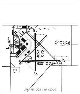
RWY 09–27: H5001X75 (ASPH) MIRL
RWY 09: REIL. PAPI(P4L)–GA 3.0° TCH 40′. Rgt tfc.
RWY 27: REIL. PAPI(P4L)–GA 3.0° TCH 40′.
RWY 18–36: H4894X75 (ASPH) MIRL
RWY 36: Rgt tfc.
SERVICE: FUEL 100LL, JET A LGT To incr ints and ACTIVATE MIRL Rwy 09–27 and Rwy 18–36, REIL Rwy 09 and Rwy 27–CTAF. PAPI Rwy 09 and Rwy 27 opr continuously.
AIRPORTREMARKS:Attended Mon–Fri 1300–2200Z‡. Parachute Jumping. Deer and birds on and invof arpt. For fuel after hrs call phone number posted on site. Seasonal mowing ops adj to rwys and twys. FBO opns Mon–Fri 1300–2200Z‡. FBO svc clsd Sat & Sun unless advn coordination is made. Twy 35′ wide in most places. 48 hrs PPR for acft with single wheel load greater than 15,000 lbs.
AIRPORT MANAGER: 217-892-6895
WEATHER DATA SOURCES: AWOS–3 119.025 (217) 892–4999.
COMMUNICATIONS: CTAF/UNICOM 123.0
®CHAMPAIGN APP/DEP CON 121.35 (1200–0500Z‡)
CHICAGO CENTER APP/DEP CON 121.35 (0500–1200Z‡)
CLEARANCE DELIVERY PHONE: For CD ctc Champaign Apch at 217-355-4071, when Apch clsd ctc Chicago ARTCC at 630-906-8921
RADIO AIDS TO NAVIGATION: NOTAM FILE CMI.
CHAMPAIGN (L) (L) VORTAC 115.75 CMI Chan 104(Y) N40°02.07′ W88°16.56′ 019° 16.7 NM to fld. 745/3E.