PINEHURST/SOUTHERN PINES
MOORE CO (SOP)(KSOP) 3 N UTC–5(–4DT) N35°14.25′ W79°23.34′ 459 B NOTAM FILE SOP
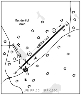
RWY 05–23: H6503X150 (ASPH–GRVD) S–100, D–162 PCN 27 F/A/X/T HIRL 0.4% up SW
RWY 05: MALSR. PAPI(P4L)–GA 3.0° TCH 40′. Thld dsplcd 600′. Trees.
RWY 23: REIL. PAPI(P4R)–GA 3.0° TCH 41′. Thld dsplcd 400′. Trees.
RUNWAY DECLARED DISTANCE INFORMATION
RWY 05: TORA–6502 TODA–6502 ASDA–6102 LDA–5502
RWY 23: TORA–6502 TODA–6502 ASDA–6102 LDA–5722
SERVICE: S4 FUEL 100LL, JET A+ OX 3 LGT ACTVT MALSR Rwy 05; REIL Rwy 23; HIRL Rwy 05–23; twy lgts–CTAF. PAPI Rwy 05 & 23 opers consly.
NOISE: Noise abatement procedures in effect. Ctc amgr 910–692–3212.
AIRPORT REMARKS: Attended 1300–0100Z‡. Bird activity on and invof arpt Apr–Oct. Fixed wing aircraft operations not authorized from any grass/turf surface. Clsd to unscheduled air carrier ops with more than 30 passenger seats, call arpt mgr 910–692–3212. 12 hr PPR for jet ops conducted 0400–1100Z‡, ctc arpt mgr 910–692–3212. Maint avbl. Flt trng avbl.
AIRPORT MANAGER: 910-692-3212
WEATHER DATA SOURCES: AWOS–3PT 127.575 (910) 692–4287.
COMMUNICATIONS: CTAF/UNICOM 123.05
®FAYETTEVILLE APP/DEP CON 127.8
CLNC DEL 127.0
CLEARANCE DELIVERY PHONE: For CD ctc Fayetteville Apch 910-484-8012.
RADIO AIDS TO NAVIGATION: NOTAM FILE RDU.
SANDHILLS (L) (L) VORTACW 111.8 SDZ Chan 55 N35°12.93′ W79°35.28′ 085° 9.9 NM to fld. 588/3W.
VOR unusable:
075°–143°
144°–154° blo 6,000′
144°–154° byd 23 NM
155°–179° blo 5,000′
180°–264° blo 8,000′
301°–019° byd 10 NM blo 10,000′
DME unusable:
041°–092° blo 3,000′
TAC AZM unusable:
016°–050° byd 28 NM blo 3,000′
ILS/DME 111.5 I–SOP Chan 52 Rwy 05. Class IT. LOC unmonitored 0100–1300Z‡.