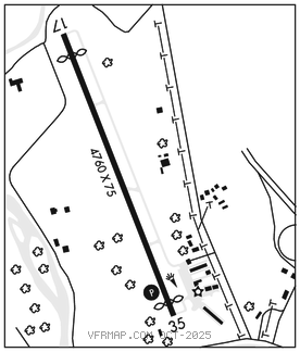
SELINSGROVE
PENN VALLEY (SEG)(KSEG) 1 N UTC–5(–4DT) N40°49.27′ W76°51.85′ 464 B NOTAM FILE SEG

RWY 17–35: H4760X75 (ASPH) S–27, D–27 MIRL 0.5% up N
RWY 17: REIL. Thld dsplcd 388′. Tree.
RWY 35: REIL. PAPI(P4L)–GA 3.5° TCH 45′. Thld dsplcd 250′. Trees.
SERVICE: S2 FUEL 100LL, JET A LGT ACTVT REIL Rwy 17 and Rwy 35; PAPI Rwy 35; MIRL Rwy 17–35–CTAF.
AIRPORT REMARKS: Attended Mon–Fri 1300–2300Z‡, Sat–Sun 1300–2100Z‡. Rising terrain both sides of apch to Rwy 17. Deer and birds on and in vicinity of arpt. Ramp fee for twin eng and lrgr acft unless fuel purchased. Cold temperature airport. Altitude correction required at or below –13C.
AIRPORT MANAGER: 570-809-4701
WEATHER DATA SOURCES: ASOS 123.975 (570) 374–4099.
COMMUNICATIONS: CTAF/UNICOM 122.7
®HARRISBURG APP/DEP CON 118.25
CLEARANCE DELIVERY PHONE: For CD ctc Harrisburg Apch at 800-932-0712.
RADIO AIDS TO NAVIGATION: NOTAM FILE SEG.
SELINSGROVE (L) (L) VORW/DME 110.4 SEG Chan 41 N40°47.45′ W76°53.04′ 034° 2.0 NM to fld. 6108W.
VOR unusable:
098°–150° byd 20 NM blo 5,000′
106°–116° byd 20 NM blo 10,000′
151°–185° byd 19 NM
250°–285° byd 10 NM blo 14,000′
295°–300° byd 25 NM blo 4,500′
DME unusable:
098°–150° byd 20 NM blo 5,000′
151°–185° byd 19 NM
255°–265° blo 7,000′
295°–300° byd 25 NM blo 4,500′