LOUISVILLE MUHAMMAD ALI INTL (SDF)(KSDF) P (ANG) 4 S UTC–5(–4DT) N38°10.45′
W85°44.19′ 501 B LRA Class I, ARFF Index C NOTAM FILE SDF
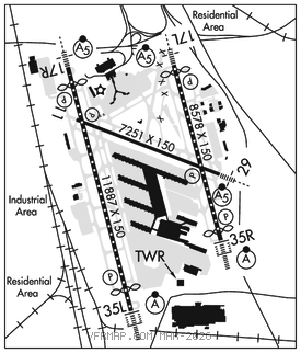
RWY 17R–35L: H11887X150 (CONC–GRVD) S–75, D–207, 2D–360, 2D/2D2–850 PCR 770 R/A/W/T HIRL CL
RWY 17R: MALSR. TDZL. PAPI(P4R)–GA 3.0° TCH 64′. RVR–TMR Thld dsplcd 846′.
RWY 35L: ALSF2. TDZL. PAPI(P4L)–GA 3.0° TCH 75′. RVR–TMR Thld dsplcd 1040′.
RWY 17L–35R: H8578X150 (CONC–GRVD) S–75, D–207, 2D–360, 2D/2D2–850 PCR 970 R/B/W/T HIRL CL
RWY 17L: MALSR. TDZL. PAPI(P4L)–GA 3.0° TCH 63′. RVR–TMR Thld dsplcd 328′. 0.4% down.
RWY 35R: ALSF2. TDZL. PAPI(P4R)–GA 3.0° TCH 71′. RVR–TMR Thld dsplcd 449′.
RWY 11–29: H7251X150 (CONC–WC) S–75, D–170, 2D–360, 2D/2D2–850 PCR 720 R/B/W/T HIRL
RWY 11: PAPI(P4L)–GA 3.0° TCH 65′. RVR–R Bldg.
RWY 29: MALSR. PAPI(P4L)–GA 3.0° TCH 56′. RVR–T
RUNWAY DECLARED DISTANCE INFORMATION
RWY 11: TORA–7250 TODA–7250 ASDA–6946 LDA–6946
RWY 17L:TORA–8579 TODA–8579 ASDA–8129 LDA–7800
RWY 17R:TORA–11095TODA–11095 ASDA–11095 LDA–10000
RWY 29: TORA–7250 TODA–7250 ASDA–7250 LDA–7250
RWY 35L:TORA–11290 TODA–11290 ASDA–11290 LDA–10000
RWY 35R:TORA–8579 TODA–8579 ASDA–8250 LDA–7800
SERVICE: S4 FUEL 100LL, JET A, A+ OX 4 MILITARY– JASU 2(MC–1A) 3(MC–2A) 7(A/M32A–86) 3(AM32–95). FUEL A, A+ (C502–368–1515) (NC–100LL)
AIRPORTREMARKS: Attended continuously. Birds on and invof arpt. CTN: Const in prog; fqt rwy and twy closures psbl. Tail hgt 65′ or gtr 24 hr PPR. Rwy 17L end, Twy E intxn dep 7700′ avbl. Rwy 35R end, Twy E2 intxn dep 6300′ avbl. Rwy 17R end, std dep points at Twy B8 and Twy A8. Reqs use of Rwy 17R extn. Tkof at Twy B8 ASDA/TORA/TODA 10245 ft. Rwy 35L end, std dep points at Twy A and Twy B. Reqs use of Rwy 35L extn. Tkof at Twy A and Twy B ASDA/TORA/TODA 10250′. Line up and wait waiver in efct SS–SR at int of Rwy 17R at Twy B8 or at Twy A8 and int of Rwy 35L at Twy A or at Twy B. ASDE–X in use. Operate transponders with altitude reporting mode and ADS–B (if equipped) enabled on all airport surfaces. Flight Notification Service (ADCUS) avbl.
MILITARY REMARKS: CAUTION: Bash info –Phase I: 1 Nov–28 Feb and 1 May–31 Aug; Phase II: 1 Sept–31 Oct and 1 Mar–30 Apr. ANG: Duty hr 1200–2000Z/DT 1300–2100Z Mon–Thu; 1200–1800Z/DT 1300–1900Z Fri. Apvl auth 123 AW/OGC; Base Ops D741–4581/4584/C502–413–4581/4584. Eng start and taxi clnc–Derby Ops. FAA GP 6 24 hr notice for PPR.
AIRPORT MANAGER: 502-380-8200
WEATHER DATA SOURCES: ASOS (502) 676–6814 LLWAS. TDWR.
COMMUNICATIONS: D–ATIS 118.725 UNICOM 122.95
®APP/DEP CON 134.15 132.075 (350°–169°) 123.675 (170°–349°)
TOWER 124.2 GND CON 121.7 CLNC DEL 126.1
CPDLC (LOGON KUSA)
PDC
AIRSPACE: CLASS C svc ctc APP CON.
VOR TEST FACILITY (VOT) 111.0
RADIO AIDS TO NAVIGATION: NOTAM FILE LOU.
(H) (H) VORTACW 114.8 IIU Chan 95 N38°06.21′ W85°34.65′ 298° 8.6 NM to fld. 7201E.
VOR unusable:
001°–025°
026°–090° blo 10,000′
100°–150° blo 9,000′
151°–180° blo 7,000′
275°–330° byd 30 NM blo 4,000′
TACAN AZIMUTH unusable:
225°–275° blo 5,000′
DME unusable:
225°–275° blo 5,000′
LAANG NDB (LOMW) 414 LK N38°08.69′ W85°38.00′ 294° 5.2 NM to fld. 6104W. NOTAM FILE SDF.
NDB unusable:
205°–245° byd 10 NM
ILS/DME 111.95 I–PKI Chan 56(Y) Rwy 17L. Class IE.
ILS/DME 110.3 I–SNU Chan 40 Rwy 17R. Class IE.
LOC 109.1 I–LKS Rwy 29. LOM LAANG NDB. LOC unusable byd 19° r and left of course.
ILS/DME 109.35 I–RLI Chan 30(Y) Rwy 35L. Class IIIE.
ILS/DME 110.55 I–JJM Chan 42(Y) Rwy 35R. Class IIIE.