WARROAD INTL MEML (RRT)(KRRT) 2 NW UTC–6(–5DT) N48°56.49′ W95°20.91′
1076 B LRA NOTAM FILE RRT
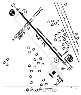
RWY 13–31: H5400X100 (ASPH) S–30, D–40 HIRL
RWY 13: MALSR. PAPI(P4L)–GA 3.0° TCH 29′.
RWY 31: MALSR. PAPI(P4L)–GA 3.0° TCH 29′.
RWY 04–22: 2987X150 (TURF)
SERVICE: FUEL 100LL, JET A LGT ACTVT or incr intst MALSR Rwy 13 and 31; HIRL Rwy 13–31–CTAF. PAPI Rwy 13 and 31 opr consly; HIRL Rwy 13–31 preset low intst. PCL unavbl durg dalgt hrs.
AIRPORT REMARKS: Attended Mon–Fri 1300–2300Z‡. For svc ngts and wkends call amgr. Deer and birds on and invof arpt. Rwy 04–22 CLOSED winter months. 100LL avbl H24 self svc via credit card. Cust avbl 1 hr PPR call 218–386–1676, cell 218–689–3880, otr: 218–386–2796. Rwy 04–22 mkd with yellow cones. Rwy 31 calm wind runway.
AIRPORT MANAGER: 218-386-1691
WEATHER DATA SOURCES: AWOS–3 119.925 (218) 386–1813.
COMMUNICATIONS: CTAF/UNICOM 123.05
MINNEAPOLIS CENTER APP/DEP CON 134.75
WARROAD RCO 122.4 (PRINCETON RADIO)
GCO Avbl on freq 121.725 (MINNEAPOLIS CENTER AND FLIGHT SERVICES).
CLEARANCE DELIVERY PHONE: For CD if una to ctc on FSS freq, ctc Minneapolis ARTCC at 651-463-5588.
RADIO AIDS TO NAVIGATION: NOTAM FILE ROX.
ROSEAU (H) DME 115.25 ROX Chan 99(Y) N48°51.29′ W95°41.63′ 069° 14.6 NM to fld. 1051.
DME unusable:
080°–115° byd 20 NM blo 3,000′
Byd 25 NM blo 2,900′
ROADD NDB (LOMW) 360 SW N48°51.77′ W95°14.51′ 314° 6.3 NM to fld. 1084/4E. NOTAM FILE RRT.
ILS/DME 110.1 I–SWE Chan 38 Rwy 31. Class IT. LOM ROADD NDB. Autopilot cpd apch NA blw 1,450′. DME unusable byd 19° r of course. Unmonitored.