RICHMOND
CENTRAL KENTUCKY RGNL (RGA)(KRGA) P (PA) 8 SW UTC–5(–4DT) N37°37.89′ W84°19.95′ 1002 B NOTAM FILE LOU
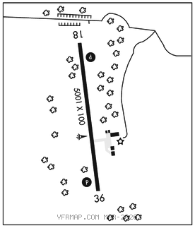
RWY 18–36: H5001X100 (ASPH) S–12.5 MIRL 0.7% up S
RWY 18: REIL. PAPI(P4L)–GA 3.0° TCH 39′.
RWY 36: REIL. PAPI(P4L)–GA 3.0° TCH 26′. Tree.
SERVICE: S4 FUEL 100LL, JET A+ LGT ACTVT REIL Rwy 18 and Rwy 36; PAPI Rwy 18 and Rwy 36; MIRL Rwy 18–36–CTAF.
AIRPORT REMARKS: Attended Mon–Fri 1300–2200Z‡, Sat 1400–2200Z‡, Sun 1600–2200Z‡. Deer and birds on and invof arpt. Student trng wi 15 NM; sfc to 7500 ft. Fuel avbl 24 hr with credit card.
AIRPORT MANAGER: 859-986-3913
WEATHER DATA SOURCES: AWOS–3 119.625 (859) 985–5969.
COMMUNICATIONS: CTAF/UNICOM 122.725
MADISON RCO 122.3 (LOUISVILLE RADIO)
®LEXINGTON APP/DEP CON 120.15
CLEARANCE DELIVERY PHONE: For CD ctc Lexington approach at 859-514-7890.
RADIO AIDS TO NAVIGATION: NOTAM FILE LEX.
LEXINGTON (VL) (L) VOR/DME 112.6 HYK Chan 73 N37°57.98′ W84°28.35′ 162° 21.1 NM to fld. 1035/0E.