RAPID CITY RGNL (RAP)(KRAP) P (ARNG) 8 SE UTC–7(–6DT) N44°02.72′ W103°03.44′
3204 B ARFF Index–See Remarks NOTAM FILE RAP MON Airport
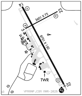
RWY 14–32: H8701X150 (CONC–GRVD) S–140, D–190, 2S–175, 2D–300 PCR 635 R/D/W/T HIRL
RWY 14: REIL. PAPI(P4L)–GA 3.0° TCH 50′. RVR–R Fence. 0.6% down.
RWY 32: MALSR. PAPI(P4L)–GA 3.0° TCH 54′. RVR–T 0.5% up.
RWY 05–23: H3601X75 (ASPH) S–12.5 PCR 80 F/C/X/T MIRL 0.8% up NE No Part 121/Part 380 Ops
RWY 05: PAPI(P2L)–GA 3.0° TCH 34′. Rgt tfc.
RWY 23: PAPI(P2L)–GA 3.0° TCH 38′. Road.
RUNWAY DECLARED DISTANCE INFORMATION
RWY 05: TORA–3601 TODA–3601 ASDA–3601 LDA–3601
RWY 14: TORA–8701 TODA–8701 ASDA–8701 LDA–8701
RWY 23: TORA–3601 TODA–3601 ASDA–3601 LDA–3601
RWY 32: TORA–8701 TODA–8701 ASDA–8701 LDA–8701
SERVICE: S4 FUEL 100LL, JET A OX 3 LGT When ATCT clsd ACTVT MALSR Rwy 32; REIL Rwy 14; HIRL Rwy 14–32; MIRL Rwy 05–23; Twy A and B lgts –CTAF. PAPI Rwys 05, 14, 23, 32 opr consly. MILITARY–FUEL ARNG ramp– A+(Mil) (NC–100LL,A)
AIRPORTREMARKS: Attended continuously. Birds on and in vicinity of arpt. 100LL and Jet A self svc avbl 24 hrs with credit card only NE side of GA ramp. Be alert: extensive military jet traffic in vicinity of and north–northwest of arpt. Be alert do not mistake Ellsworth AFB, located 6.5 NM north–northwest for Rapid City Rgnl. 152′ AGL twr 2.5 NM north–northwest of arpt. Line of sight is restricted between Rwy 14 and Rwy 23 physical ends. Twr has limited visibility of Twy T1 and Twy T2 and Twy B at AER 23. Rwy 05–23 not avbl to acft over 12,500 lbs to taxi. Class I, ARFF Index B. ARFF Index C avbl upon req. Diverting non–based air carriers ctc arpt ops at 605–593–3419 prior to diverting due to limited gate space. Ctc ground for free tie–down locations, or call arpt opr at 605–593–3419. All charter serviced acft over 12,500 lbs must ctc arpt ops at 605–593–3419 at least 48 hrs prior to arrival. Overnight parking allowed in designated tiedown areas only. No cstms svc avbl. Landing fee for acft over 12,500 lbs or greater.
AIRPORT MANAGER: 605-394-4195
WEATHER DATA SOURCES: ASOS 118.525 (605) 223–0202.
COMMUNICATIONS: CTAF 125.85 UNICOM 122.95
RCO 122.4 (HURON RADIO)
RCO 122.1R 112.3T (HURON RADIO)
®ELLSWORTH APP/DEP CON 119.5 (H24 1300Z‡ Mon thru 0500Z‡ Sat, 1300–0500Z‡ Sat–Sun, other times ctc Denver Center: 127.95 338.2)
TOWER 125.85 (1300–0500Z‡) GND CON 121.9
CLEARANCE DELIVERY PHONE: For CD ctc gnd or ATCT on freq. If una, ctc rap ATCT at 605-393-1161. When ATCT clsd, ctc Ellsworth Apch at 605-385-6198. When Apch clsd ctc Denver ARTCC at 303-651-4257.
AIRSPACE: CLASS D svc 1300–0500Z‡; other times CLASS E.
RADIO AIDS TO NAVIGATION: NOTAM FILE RAP.
(VH) (H) VORTAC 112.3 RAP Chan 70 N43°58.56′ W103°00.74′ 322° 4.6 NM to fld. 3157/13E.
VOR unusable:
215°–232° byd 40 NM
233°–243° byd 40 NM blo 8,300′
233°–243° byd 81 NM blo 18,000′
244°–253° byd 40 NM blo 8,000′
244°–253° byd 61 NM
254°–264° byd 40 NM blo 18,000′
ILS/DME 109.3 I–RAP Chan 30 Rwy 32. Class IE. Glideslope unusable for coupled approaches blo 3,360′. LOC unusable byd 27° left of course byd 27° r of course.
COMM/NAV/WEATHER REMARKS: High vol of heli tours invof Mt. Rushmore and Crazy Horse Monuments at or blw 7500′; all otr acft should rmn at or above 7700′ and maintain 1 NM horizontal separation from the monuments; pilots are advised to monitor 122.85 for tfc advisories.