PINE RIVER RGNL (PWC)(KPWC) 1 E UTC–6(–5DT) N46°43.49′ W94°22.90′
1296 NOTAM FILE PWC
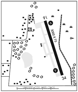
RWY 16–34: H3000X75 (ASPH) MIRL
RWY 16: REIL. VASI(V2L)–GA 3.0° TCH 22′.
RWY 34: REIL. VASI(V2L)–GA 3.0° TCH 22′.
SERVICE: FUEL 100LL LGT ACTVT or incr intst REIL Rwy 16 and 34; VASI Rwy 16 and 34; MIRL Rwy 16–34–CTAF. MIRL Rwy 16–34 preset med intst.
AIRPORT REMARKS: Unattended. Deer and waterfowl on and invof arpt. Ultralights on and invof arpt. For emerg call 218–821–3521. Fuel avbl H24 self ser via credit card. Aft hrs call 218–821–3521. Cfm snow removal and winter conds call 218–821–3521. Rwy 34 calm wind rwy.
AIRPORT MANAGER: 218-587-2440
WEATHER DATA SOURCES: AWOS–3PT 118.525 (218) 587–3420.
COMMUNICATIONS: CTAF 122.9
®MINNEAPOLIS CENTER APP/DEP CON 118.05
CLEARANCE DELIVERY PHONE: For CD ctc Minneapolis ARTCC at 651-463-5588.
RADIO AIDS TO NAVIGATION: NOTAM FILE PKD.
PARK RAPIDS (L) DME 110.6 PKD Chan 43 N46°53.89′ W95°04.26′ 110° 30.3 NM to fld. 1472.