PHILIP (PHP)(KPHP) 3 E UTC–7(–6DT) N44°02.92′ W101°35.93′
2209 B NOTAM FILE PHP
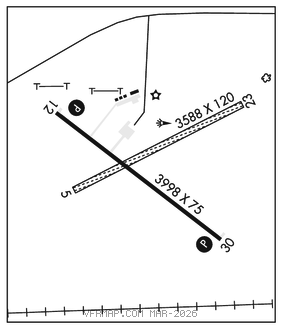
RWY 12–30: H3998X75 (ASPH) S–12.5 MIRL 0.4% up NW
RWY 12: PAPI(P2L)–GA 3.0° TCH 31′. Pole.
RWY 30: PAPI(P2L)–GA 3.0° TCH 27′.
RWY 05–23: 3588X120 (TURF)
RWY 23: Tree.
SERVICE: FUEL 100LL LGT ACTIVATE PAPI Rwy 12–30, MIRL Rwy 12–30–CTAF.
AIRPORT REMARKS: Unattended. Fuel avbl 24 hrs with credit card. Rwy 05–23 marked with black/white cones.
AIRPORT MANAGER: 605-859-2175
WEATHER DATA SOURCES: ASOS 118.375 (605) 206–3001.
COMMUNICATIONS: CTAF/UNICOM 122.8
RCO 122.4 (HURON RADIO)
®DENVER CENTER APP/DEP CON 127.95
CLEARANCE DELIVERY PHONE: For CD if una to ctc on FSS freq, ctc Denver ARTCC at 303-651-4257.
RADIO AIDS TO NAVIGATION: NOTAM FILE PHP.
(VL) (DH) VORW/DME 115.55 PHP Chan 102(Y) N44°03.49′ W101°39.85′ 089° 2.9 NM to fld. 234012E.
VOR unusable:
230°–235° byd 40 NM
245°–250° byd 40 NM
250°–325° byd 30 NM blo 4,500′
255°–262° byd 40 NM
263°–270° byd 54 NM
310°–315° byd 40 NM
DME unusable:
285°–320°