PELLA MUNI (PEA)(KPEA) 1 W UTC–6(–5DT) N41°24.07′ W92°56.75′
885 B TPA–1701(816) NOTAM FILE PEA
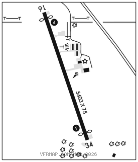
RWY 16–34: H5403X75 (CONC) S–30, D–40 PCN 8 R/D/W/T MIRL 0.3% up NW
RWY 16: REIL. PAPI(P2L)–GA 3.3° TCH 26′. Thld dsplcd 200′. Tree.
RWY 34: REIL. PAPI(P2L)–GA 3.0° TCH 46′. Thld dsplcd 201′. Trees.
RUNWAY DECLARED DISTANCE INFORMATION
RWY 16: TORA–5400 TODA–5400 ASDA–5200 LDA–5000
RWY 34: TORA–5400 TODA–5400 ASDA–5200 LDA–5000
SERVICE: S4 FUEL 100LL, JET A LGT MIRL Rwy 16–34 preset low ints, to incr ints and ACTIVATE PAPI Rwy 16 and Rwy 34, REIL Rwy 16 and Rwy 34–CTAF.
AIRPORTREMARKS:Attended Mon–Sat 1300Z‡–dusk, Sun 1500–2300Z‡. After hrs call 641–780–0244. Traffic pattern alt only applies to non–turbine acft.
AIRPORT MANAGER: 641-628-9393
WEATHER DATA SOURCES: AWOS–3 118.875 (641) 628–3459.
COMMUNICATIONS: CTAF/UNICOM 122.8
®DES MOINES APP/DEP CON 123.9
CLEARANCE DELIVERY PHONE: For CD ctc Des Moines ATCT at 515-974-8016.
RADIO AIDS TO NAVIGATION: NOTAM FILE TNU.
NEWTON (L) (L) VORW/DME 112.5 TNU Chan 72 N41°47.03′ W93°06.54′ 159° 24.1 NM to fld. 989/3E.