OWATONNA DEGNER RGNL (OWA)(KOWA) 3 NW UTC–6(–5DT) N44°07.38′ W93°15.53′
1145 B TPA–1997(852) NOTAM FILE OWA
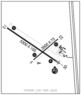
RWY 12–30: H5500X100 (CONC) S–30, D–60 HIRL 0.7% up SE
RWY 12: REIL. PAPI(P4L)–GA 3.0° TCH 40′.
RWY 30: MALSR. PAPI(P4L)–GA 3.0° TCH 50′. Sign.
RWY 05–23: H3000X75 (ASPH) MIRL
RWY 05: REIL. PAPI(P4L)–GA 3.0° TCH 24′.
RWY 23: REIL. PAPI(P4L)–GA 3.0° TCH 23′.
SERVICE: S4 FUEL 100LL, JET A LGT ACTIVATE MIRL Rwy 05–23, MALSR Rwy 30, REIL Rwy 05, Rwy 12, and Rwy 23, HIRL Rwy 12–30, PAPI Rwy 05, Rwy 12, Rwy 23 and Rwy 30–CTAF.
AIRPORT REMARKS: Attended May–Sep Mon–Fri 1400–2300Z‡, May–Sep Sat–Sun 1600–2200Z‡, Oct–Apr Mon–Fri 1400–2300Z‡, Oct–Apr Sat–Sun 1700–2100Z‡. Fuel: 100LL avbl 24 hrs with credit card. Jet A after hrs call 507–774–7141. Ultralights on and invof arpt.
AIRPORT MANAGER: 507-774-7141
WEATHER DATA SOURCES: AWOS–3 128.325 (507) 455–0642.
COMMUNICATIONS: CTAF/UNICOM 122.7
RCO 122.2 (PRINCETON RADIO)
®ROCHESTER APP/DEP CON 119.8 (1100–0500Z‡)
®MINNIEAPOLIS CENTER APP/DEP CON 132.35 (0500–1100Z‡)
CLEARANCE DELIVERY PHONE: For CD ctc Rochester Apch at 507-424-8111.
RADIO AIDS TO NAVIGATION: NOTAM FILE PNM.
HALFWAY (T) (T) VORW/DME 111.2 FOW Chan 49 N44°12.27′ W93°22.23′ 133° 6.9 NM to fld. 1099/2E. VOR/DME unmonitored.
ILS/DME 109.55 I–OWA Chan 32(Y) Rwy 30. Class IT. Unmonitored.