OHIO STATE UNIVERSITY (OSU)(KOSU) P (NG) 10 NW UTC–5(–4DT) N40°04.77′ W83°04.39′
906 B Class IV, ARFF Index A NOTAM FILE OSU
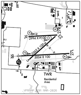
RWY 09R–27L: H5004X100 (ASPH–GRVD) S–120, D–250, 2D–550, 2D/2D2–1061 PCR 860 F/C/X/T HIRL No Part 121/Part 380 Ops
RWY 09R: MALSR. PAPI(P4L)–GA 3.0° TCH 51′.
RWY 27L: REIL. PAPI(P4L)–GA 3.0° TCH 28′. Tree.
RWY 05–23: H3562X100 (ASPH) S–76, D–122, 2D–206 PCR 290 F/B/X/T 0.3% up SW No Part 121/Part 380 Ops
RWY 05: Trees.
RWY 23: Trees.
RWY 09L–27R: H2994X100 (ASPH) S–63, D–91, 2D–154 PCR 240 F/C/X/T MIRL 0.4% up W No Part 121/Part 380 Ops
RWY 09L: VASI(V2L)–GA 3.0° TCH 27′.
RWY 27R: VASI(V2L)–GA 3.0° TCH 31′. Trees.
RUNWAY DECLARED DISTANCE INFORMATION
RWY 05: TORA–3562 TODA–3562 ASDA–3562 LDA–3562
RWY 09L:TORA–2994 TODA–2994 ASDA–2994 LDA–2994
RWY 09R:TORA–5004 TODA–5004 ASDA–5004 LDA–5004
RWY 23: TORA–3562 TODA–3562 ASDA–3562 LDA–3562
RWY 27L:TORA–5004 TODA–5004 ASDA–5004 LDA–5004
RWY 27R:TORA–2994 TODA–2994 ASDA–2994 LDA–2994
SERVICE: S4 FUEL 100LL, JET A1+ OX 1, 2 LGT When ATCT clsd ACTVT MALSR Rwy 09R–CTAF. REIL Rwy 27L; PAPI Rwy 09R & 27L; VASI Rwy 09L & 27R; HIRL Rwy 09R–27L – opr consly med intst. MIRL Rwy 09L–27R – opr consly low intst. MILITARY– FUEL (NC–100LL, A1+)
NOISE: Noise sensitive area within 4 miles to the north and northeast. Noise abatement rstrns: No TGL or rptd tkof/lndg 0400–1200Z‡ dly.
AIRPORT REMARKS: Attended 1100–0400Z‡. Birds & deer on & invof arpt. Sfc conds unmon 0400–1200Z‡. Rwy 05–23 CLOSED dly SS–SR. All twys north of Rwy 09R–27L clsd to unsked ACR ops gtr than 30 pax seats. Clsd to Part 121 skedd ACR ops gtr than 9 pax seats; 90 day PPR for unsked ACR ops gtr than 30 pax seats–call amgr. Rwy 05–23, Rwy 09L–27R and Rwy 09R–27L, 90 day PPR for unsked ACR ops gtr than 30 pax seats–call amgr. Closed ramp north of Twy G 24 hour PPR for use 614–292–5617. Snow removal operating procedures: when twr clsd, announce arrs/deps on freq 118.8.
AIRPORT MANAGER: 614-292-4229
WEATHER DATA SOURCES: ASOS 121.35 (614) 451–2465. LAWRS.
COMMUNICATIONS: CTAF 118.8 ATIS 121.35 UNICOM 122.95
®COLUMBUS APP/DEP CON 125.95
STATE TOWER 118.8 (1200–0400Z‡) GND CON 121.7 CLNC DEL 121.7
AIRSPACE: CLASS D svc 1200–0400Z‡; other times CLASS G.
RADIO AIDS TO NAVIGATION: NOTAM FILE DAY.
APPLETON (VH) (H) VORTAC 116.7 APE Chan 114 N40°09.06′ W82°35.30′ 265° 22.7 NM to fld. 1354/6W.
VOR unusable:
025°–030°
TACAN AZIMUTH unusable:
075°–095°
110°–115°
DME unusable:
075°–080°
FULER NDB (MHW/LOM) 515 OS N40°04.42′ W83°11.88′ 091° 5.8 NM to fld. 941/5W. NOTAM FILE OSU.
ILS 108.5 I–OSU Rwy 09R. Class IT. LOM FULER NDB. Unmonitored.
COMM/NAV/WEATHER REMARKS: Emerg frequency 121.5 not avbl at twr. • • • • • • • • • • • • • • • • • •
HELIPAD H1: H40X40 (ASPH)
HELIPORT REMARKS: Heliport (unlit) located north side of airfield, adjacent Air Guard ramp, Twy G. Helicopter lndgs/tkfs prohibited on Twy A and all ramp area south of Twy A. Helicopters ground taxi if capable on Twy A abeam ramp. When able, helicopters use 1900 MSL as traffic pattern altitude.