OKMULGEE RGNL/PAUL AND BETTY ABBOTT FLD (OKM)(KOKM) 3 N UTC–6(–5DT)
N35°40.09′ W95°56.91′ 720 B NOTAM FILE OKM
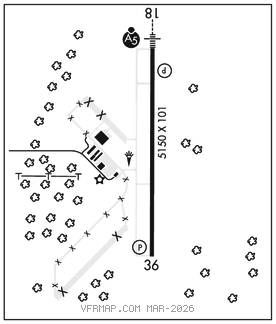
RWY 18–36: H5150X101 (CONC) S–30, D–48, 2D–78 MIRL 0.7% up N
RWY 18: MALSR. PAPI(P4L)–GA 3.0° TCH 51′.
RWY 36: PAPI(P4L)–GA 3.0° TCH 40′.
SERVICE: S4 FUEL 100LL, JET A+ LGT ACTVT MALSR Rwy 18 and incr intst–CTAF; PAPI Rwy 18 and Rwy 36 on consly; MIRL Rwy 18–36 on low SS–SR, incr intst–CTAF.
AIRPORTREMARKS: Attended Mon–Sat 1400–2300Z‡. Parachute Jumping. Flocks of migratory birds and deer on and invof arpt. 100LL 24 hr fuel automated credit card system.
AIRPORT MANAGER: 918-756-0412
WEATHER DATA SOURCES: AWOS–3PT 118.225 (918) 756–9502.
COMMUNICATIONS: CTAF/UNICOM 123.0
®TULSA APP/DEP CON 119.85
CLEARANCE DELIVERY PHONE:For CD ctc Tulsa app/dep ctl at 918-831-6714.
RADIO AIDS TO NAVIGATION: NOTAM FILE OKM.
(VH) (DH) VORW/DME 114.9 OKM Chan 96 N35°41.58′ W95°51.96′ 242° 4.3 NM to fld. 774/8E.
TULSA (H) (H) VORTACW 114.4 TUL Chan 91 N36°11.78′ W95°47.29′ 186° 32.6 NM to fld. 788/8E. NOTAM FILE TUL.
TACAN AZIMUTH unusable:
248°–258° byd 23 NM blo 3,100′
DME unusable: 248°–258° byd 23 NM blo 3,100′
ILS 109.1 I–OKM Rwy 18. Unmonitored.