WASHINGTON–WARREN (OCW)(KOCW) 0 NE UTC–5(–4DT) N35°34.23′ W77°02.99′
37 B NOTAM FILE OCW
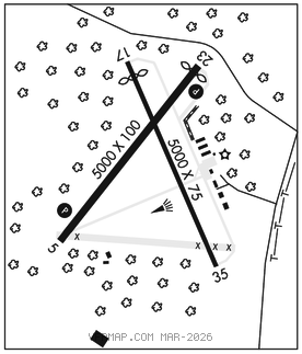
RWY 05–23: H5000X100 (ASPH) S–30, D–38 MIRL
RWY 05: REIL. PAPI(P2L)–GA 3.0° TCH 46′. Trees.
RWY 23: REIL. PAPI(P2L)–GA 3.75° TCH 45′. Thld dsplcd 200′. Road.
RWY 17–35: H5000X75 (ASPH–CONC) S–22
RWY 17: Thld dsplcd 500′. Pole.
RWY 35: Trees.
SERVICE: S2 FUEL 100LL, JET A1+ LGT MIRL Rwy 05–23 preset low intst; to incr intst and ACTVT PAPIs Rwy 05 and 23, and REILs Rwy 05–23–CTAF. Rwy 17–35 unlgtd. Twys not lgtd.
AIRPORT REMARKS: Attended Mon–Sat 1300–2200Z‡ and Sun 1500–2200Z‡. Unatndd New Years Day, Easter, July 4th, Thanksgiving and Christmas. Deer and birds on and invof arpt. For svc after hrs call 252–946–3900. Fuel 24 hr credit card svc avbl. Rwy 17 dsplcd thld not mkd at stated dist of 500′ but at 1073′ on rwy. 120′+ twr 3700′+ fm Rwy 05 thld on cntrln.
AIRPORT MANAGER: 252-946-3900
WEATHER DATA SOURCES: AWOS–3 120.175 (252) 975–6133.
COMMUNICATIONS: CTAF/UNICOM 122.7
®CHERRY POINT APP/DEP CON 119.35
CLEARANCEDELIVERY PHONE: For CD ctc Cherry Point Apch at 252-466-5960.
RADIO AIDS TO NAVIGATION: NOTAM FILE ISO.
KINSTON (VL) (L) VORTAC 117.5 ISO Chan 122 N35°22.26′ W77°33.50′ 069° 27.6 NM to fld. 705W.
VOR unusable:
020°–025° byd 40 NM
040°–115° byd 40 NM
145°–155° byd 40 NM
175°–185° byd 40 NM
183°–215° byd 30 NM blo 5,000′
200°–206° byd 40 NM
207°–214° byd 59 NM
215°–238° blo 3,500′
215°–238° byd 6 NM
238°–258° byd 30 NM blo 5,000′
239°–265° byd 40 NM
280°–290° byd 40 NM
295°–308° byd 40 NM
309°–319° byd 31 NM
320°–325° byd 40 NM
335°–340° byd 40 NM
345°–347° byd 40 NM
348°–358° byd 20 NM
TACAN AZIMUTH unusable:
183°–215° byd 30 NM blo 5,000′
DME unusable:
183°–215° byd 30 NM blo 5,000′
CHOCOWINITY NDB (MHW) 388 RNW N35°30.58′ W77°06.40′ 045° 4.6 NM to fld. 44/8W. NOTAM FILE OCW.
LOC/DME 110.9 I–OCW Chan 46 Rwy 05. LOC and DME unmonitored.