MONTEVIDEO–CHIPPEWA CO (MVE)(KMVE) 2 N UTC–6(–5DT) N44°58.15′ W95°42.62′
1034 B NOTAM FILE MVE
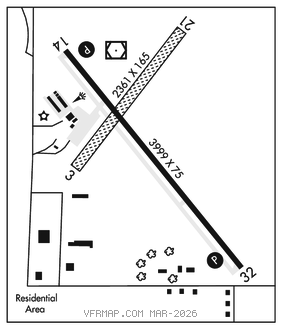
RWY 14–32: H3999X75 (ASPH) S–12.5 MIRL 0.4% up NW
RWY 14: REIL. PAPI(P4L)–GA 3.0° TCH 25′.
RWY 32: REIL. PAPI(P4L)–GA 3.0° TCH 25′.
RWY 03–21: 2361X165 (TURF) 0.5% up SW
RWY 21: Brush.
SERVICE: S4 FUEL 100LL LGT MIRL preset to low SS–SR; to incr ints and ACTIVATE REIL Rwy 14 and Rwy 32; PAPI Rwy 14 and Rwy 32–CTAF.
AIRPORT REMARKS: Attended Mon–Fri 1400–2300Z‡. Fuel self svc 24 hrs with credit card. Ultralights on and invof arpt. Rwy 03–21 not plowed winter months. Rwy 03–21 thlds and edges marked with yellow cones.
AIRPORT MANAGER: 320-269-4829
WEATHER DATA SOURCES: AWOS–3PT 119.675 (320) 269–5830.
COMMUNICATIONS: CTAF/UNICOM 122.8
RCO 122.4 (PRINCETON RADIO)
®MINNEAPOLIS CENTER APP/DEP CON 125.5
CLEARANCEDELIVERYPHONE:For CD if una to ctc on FSS freq, ctc Minneapolis ARTCC at 651-463-5588.
RADIO AIDS TO NAVIGATION: NOTAM FILE MVE.
(T) (T) VORW/DME 111.6 MVE Chan 53 N44°58.36′ W95°42.73′ at fld. 1037/5E. TVOR/DME unmonitored.
VOR unusable:
080°–150°
185°–195°