MORGANTON
FOOTHILLS RGNL (MRN)(KMRN) 6 NE UTC–5(–4DT) N35°49.21′ W81°36.69′ 1270 B NOTAM FILE MRN
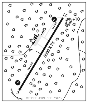
RWY 03–21: H5500X75 (ASPH) D–60 MIRL 0.7% up NE
RWY 03: REIL. PAPI(P4L)–GA 3.0° TCH 66′. Trees.
RWY 21: REIL. PAPI(P4R)–GA 3.5° TCH 48′. Trees.
SERVICE: S4 FUEL 100LL, JET A1+ OX1, 4 LGT ACTVT REILs Rwy 03 and 21; PAPI Rwy 03 and 21; MIRL Rwy 03–21–CTAF.
AIRPORT REMARKS: Attended Mon–Sat 1300–2200Z‡, Sun 1400–2200Z‡. After hrs fuel or svc call 828–757–0099. Deer and coyote on and invof arpt. Hang glider act dalgt hrs–east side of Rwy 03–21 in rwy safety area. Rwy 03, 100′ dropoff 330′ from thld and 80′ both sides of cntrln along first 1000′ of rwy. Rwy 21, 30′ dropoff 400′ from thld both sides and 10′ dropoff 50′ from thld and 150′ rgt of cntrln. Apron tie down space ltd.
AIRPORT MANAGER: 828-757-0099
WEATHER DATA SOURCES: AWOS–3P 124.175 (828) 757–0788.
COMMUNICATIONS: CTAF/UNICOM 122.7
®ATLANTA CENTER APP/DEP CON 125.15
CLEARANCE DELIVERY PHONE: For CD ctc Atlanta ARTCC at 770-210-7692.
RADIO AIDS TO NAVIGATION: NOTAM FILE RDU.
BARRETTS MOUNTAIN (H) (H) VOR/DME 113.75 BZM Chan 84(Y) N35°52.13′ W81°14.43′ 267° 18.3 NM to fld. 18806W.
VOR unusable:
030°–040° byd 15 NM blo 8,500′
107°–117° byd 30 NM
FIDDLERS NDB (MHW) 391 FIQ N35°42.61′ W81°40.28′ 031° 7.2 NM to fld. 1165/7W.
NDB unusable:
Byd 20 NM
LOC 111.1 I–MRN Rwy 03.