MILLARD (MLE)(KMLE) 7 SW UTC–6(–5DT) N41°11.76′ W96°06.74′
1051 B NOTAM FILE MLE
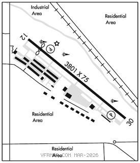
RWY 12–30: H3801X75 (ASPH) S–25, D–28 MIRL
RWY 12: REIL. PAPI(P2L)–GA 3.08° TCH 42′. Thld dsplcd 212′. Road.
RWY 30: PAPI(P2L)–GA 3.08° TCH 41′.
RUNWAY DECLARED DISTANCE INFORMATION
RWY 12: TORA–3801 TODA–3801 ASDA–3801 LDA–3588
RWY 30: TORA–3801 TODA–3801 ASDA–3588 LDA–3801
SERVICE: S4 FUEL 100LL, JET A1+ OX 1, 2, 3, 4 LGT ACTIVATE MIRL Rwy 12–30 and REIL Rwy 12–CTAF.
NOISE: After takeoff on Rwy 30 alter heading 20° to the right to avoid noise sensitive area.
AIRPORT REMARKS: Attended 1230–0300Z‡. For svc after 0300Z‡ call 402–953–9905 or 402–690–3099. Deer on and invof arpt. Radio controlled acft occasional operation 1.7 miles SW of arpt. Self–svc fuel avbl 24 hrs with credit card. Military jet overflying at 3000′ MSL. Normal calm and cross wind tkfs and ldgs on Rwy 12. No intersection tkfs. VFR acft requesting flight following and IFR acft should contact Omaha Apch on freq 125.4 prior to taking the rwy for clnc/traffic advisories/general info.
AIRPORT MANAGER: 402-661-8000
WEATHER DATA SOURCES: AWOS–3 118.25 (402) 895–6778.
COMMUNICATIONS: CTAF/UNICOM 123.0
®OMAHA APP/DEP CON 135.875
CLNC DEL 125.4
RADIO AIDS TO NAVIGATION: NOTAM FILE FOD.
OMAHA (VH) (H) VORTAC 116.3 OVR Chan 110 N41°10.03′ W95°44.21′ 268° 17.1 NM to fld. 13008E.