MARCO ISLAND EXEC (MKY)(KMKY) 4 NE UTC–5(–4DT) N25°59.70′ W81°40.35′
5 B NOTAM FILE MIA
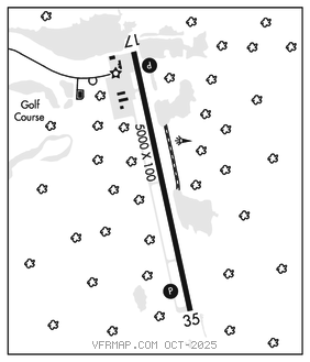
RWY 17–35: H5000X100 (ASPH–GRVD) S–75, D–108 PCN 26 F/A/W/T MIRL
RWY 17: REIL. PAPI(P4L)–GA 3.0° TCH 31′. Brush.
RWY 35: REIL. PAPI(P4L)–GA 3.0° TCH 32′. Brush. Rgt tfc.
SERVICE: S2 FUEL 100LL, JET A, A+ LGT ACTVT REIL RWY 17 and Rwy 35; PAPI RWY 17 and RWY 35; MIRL RWY 17–35–CTAF.
NOISE: Noise sensitive area. Use NBAA close in noise abatement procedures.
AIRPORTREMARKS:Attended 1200–0000Z‡. Numerous birds and wildlife on and invof arpt. Banner towing on and invof arpt. Self–svc AVGAS 100LL avbl 24 hrs by credit card. For fuel and svc after hrs call 239–394–3355. Arpt visibility unreliable. Rwy 35 dsgnd calm wind rwy for arrs 0300–1200Z‡. Rwy 17 dsgnd calm wind rwy for deps 0300–1200Z‡. Fm Nov 1st to Apr 30th–24 hr PPR req for acft ovngt prkg. Lndg fee: Ramp fee.
AIRPORT MANAGER: 239-252-8425
WEATHER DATA SOURCES: AWOS–3PT 120.075 (239) 394–8187.
COMMUNICATIONS: CTAF/UNICOM 122.7
®FORT MYERS APP/DEP CON 124.125 (1100–0500Z‡)
®MIAMI CENTER APP/DEP CON 134.75 (0500–1100Z‡)
CLNC DEL 120.8
CLEARANCE DELIVERY PHONE: For CD ctc Fort Myers Apch at239-416-1026, when Apch clsd ctc Miami ARTCC at 305-716-1731.
RADIO AIDS TO NAVIGATION: NOTAM FILE APF.
CYPRESS (L) DME 108.6 CYY Chan 23 N26°09.21′ W81°46.69′ 149° 11.1 NM to fld. 9.
DME unusable:
215°–315°