MUSKOGEE–DAVIS RGNL (MKO)(KMKO) 6 S UTC–6(–5DT) N35°39.47′ W95°21.70′
612 B NOTAM FILE MKO
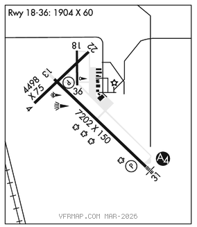
RWY13–31:H7202X150 (ASPH) S–59, D–78, 2S–99, 2D–131 MIRL 0.4% up NW
RWY 13: REIL. PAPI(P4L)–GA 3.0° TCH 50′.
RWY 31: MALS. PAPI(P4L)–GA 3.0° TCH 53′.
RWY 04–22: H4498X75 (ASPH) 0.3% up SW
RWY 04: Trees.
RWY 18–36: H1904X60 (ASPH)
SERVICE: S2 FUEL 100LL, JET A+ LGT ACTVT MALS Rwy 31; REIL Rwy 13; MIRL Rwy 13–31–CTAF. PAPI Rwy 13 and 31 on consly.
AIRPORT REMARKS: Attended Mon–Sat 1400–2300Z‡. 100LL avbl 24 hrs self svc. After hrs fuel call 918–869–8410. Arpt used for Oklahoma National Guard ATC training events– irregular schedule, contact twr on 118.95 when operational. Occasional coyotes on & invof rwy. Twy B clsd to acft over 25,000 lbs.
AIRPORT MANAGER: 918-684-6234
WEATHER DATA SOURCES: ASOS 135.025 (918) 683–6987.
COMMUNICATIONS: CTAF/UNICOM 122.8
RCO 122.5 (MC ALESTER RADIO)
®FORT WORTH CENTER APP/DEP CON 132.2
CLEARANCE DELIVERY PHONE: For CD if una to ctc on FSS freq, ctc Fort Worth ARTCC at 817-858-7584.
RADIO AIDS TO NAVIGATION: NOTAM FILE TUL.
TULSA (H) (H) VORTACW 114.4 TUL Chan 91 N36°11.78′ W95°47.29′ 139° 38.4 NM to fld. 788/8E.
TACAN AZIMUTH unusable:
248°–258° byd 23 NM blo 3,100′
DME unusable:
248°–258° byd 23 NM blo 3,100′