MITCHELL MUNI (MHE)(KMHE) 3 N UTC–6(–5DT) N43°46.49′ W98°02.32′
1304 B NOTAM FILE MHE
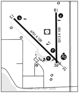
RWY 13–31: H6701X100 (ASPH) S–55, D–90, 2S–114, 2D–120 HIRL
RWY 13: REIL. PAPI(P4L)–GA 3.0° TCH 45′.
RWY 31: MALSR. PAPI(P4L)–GA 3.0° TCH 61′.
RWY 18–36: H5513X100 (ASPH–PFC) S–35, D–90, 2S–114, 2D–110 MIRL 0.4% up S
RWY 18: REIL. PAPI(P4L)–GA 3.0° TCH 55′.
RWY 36: PAPI(P4L)–GA 3.0° TCH 50′.
SERVICE: S4 FUEL 100LL, JET A LGT ACTIVATE MALSR Rwy 31; REIL Rwy 13 and Rwy 18; PAPI Rwy 13, 31, 18 and 36; HIRL Rwy 13–31; MIRL Rwy 18–36–CTAF.
AIRPORT REMARKS: Attended 1400–0000Z‡. For attendant other hrs call 605–996–1228. Fuel avbl 24 hrs a day. Ultralight activity on and invof arpt. Migratory birds on and invof arpt.
AIRPORT MANAGER: 605-770-4594
WEATHER DATA SOURCES: ASOS 124.175 (605) 995–5803.
COMMUNICATIONS: CTAF/UNICOM 122.8
RCO 122.3 (HURON RADIO)
®MINNEAPOLIS CENTER APP/DEP CON 126.25
CLEARANCEDELIVERY PHONE: For CD if una to ctc on FSS freq, ctc Minneapolis ARTCC at 651-463-5588.
AIRSPACE: CLASS E.
RADIO AIDS TO NAVIGATION: NOTAM FILE MHE.
(VL) (L) VORW/DME 114.15 MHE Chan 88(Y) N43°46.62′ W98°02.25′ at fld. 1298/4E.
VOR unusable:
059°–075° byd 70 NM
165°–175° byd 40 NM
183°–213° byd 40 NM
211°–228° byd 40 NM
231°–271° byd 40 NM
DME unusable:
178°–188° byd 40 NM
205°–217° byd 40 NM
ILS 109.7 I–LPA Rwy 31. Class IT. Glideslope unusable for autopilot coupled apch blo 2,174′ MSL. Unmonitored.