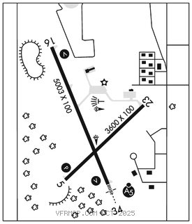
MARSHFIELD MUNI (MFI)(KMFI) 1 S UTC–6(–5DT) N44°38.21′ W90°11.36′
1278 B NOTAM FILE MFI

RWY 16–34: H5003X100 (ASPH) S–35, D–50 MIRL 0.5% up N
RWY 16: REIL. VASI(V2L)–GA 3.0° TCH 33′. Trees. Rgt tfc.
RWY 34: MALSR. VASI(V2L)–GA 3.0° TCH 41′. Trees.
RWY 05–23: H3600X100 (ASPH) S–35, D–45 MIRL
RWY 05: PAPI(P2L)–GA 3.0° TCH 29′. Trees. Rgt tfc.
SERVICE: S3 FUEL 100LL, JET A+ LGT MIRL Rwy 05–23 and Rwy 16–34 preset to low SS–SR; to incr intst and ACTVT MALSR Rwy 34; REIL Rwy 16; VASI Rwy 16 and 34; PAPI Rwy 05; MIRL Rwy 05–23 and Rwy 16–34–CTAF.
AIRPORTREMARKS: Attended 1400–2300Z‡ Mon–Sat. For after hrs svc call 715–743–6634. 24 hr fuel avbl with credit card. Rwy 34 departing acft climb to 2000′ MSL prior to initiating rgt turn. Birds, waterfowl, deer on & invof arpt.
AIRPORT MANAGER: 715-387-2211
WEATHER DATA SOURCES: ASOS 121.575 (715) 384–3046.
COMMUNICATIONS: CTAF/UNICOM 123.0
RCO 122.5 (GREEN BAY RADIO)
®MINNEAPOLIS CENTER APP/DEP CON 124.4
CLEARANCE DELIVERY PHONE: For CD if una to ctc on FSS freq, ctc Minneapolis ARTCC at 651-463-5588.